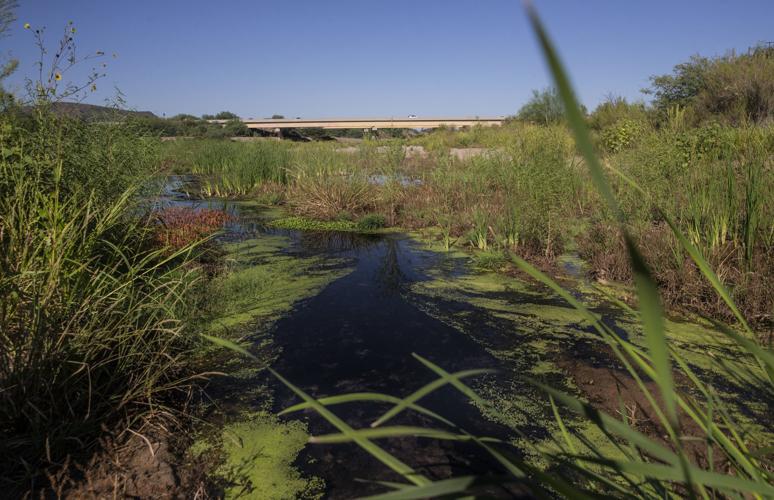
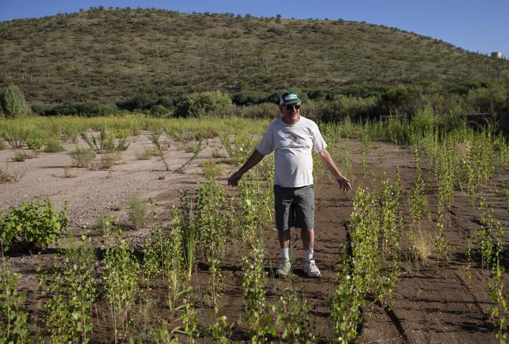
Cottonwood shoots along the Santa Cruz River near Mission San Xavier stand 2 or 3 feet tall. Some seep willows т members of the sunflower family т are just a little shorter. Cattails jut 3 feet high, next to a pondlike stream. Duckweed floats, its roots dipping ever so slightly underwater.
тThis is quite the little ecosystem,т marveled Roy Johnson, 87, a retired riparian ecologist who has been studying and writing about the river since the 1950s.
тThis is amazing,т he said, observing the rebirth of the Santa Cruz after a century of decline. тI can die happy.т
The river is carrying year-round flows down a stretch on the Tohono Oтodham Nationтs San Xavier District that until recently was dry for more than 70 years except after big rains.
And here, unlike through downtown УлшжжБВЅ, the water is once again coming up from the aquifer naturally т not being added artificially through effluent.
People are also reading…
The newfound stream is the ultimate sign of the Tohono OтOdhamтs successful struggle over the past few decades to gain back a water supply that was taken from them through groundwater pumping by non-Native Americans.
Native Americans have lived for thousands of years along this river, which was usually running wide with perennial water.
The river is why Mission San Xavier del Bac was built just a mile to the east, when Spanish explorers of more than three centuries ago dreamed of harnessing its power to grow crops and raise livestock.
An aquifer with water dating back nearly 12,000 years, to the Pleistocene Era, fed the Santa Cruz.

A caterpillar on a small stick protruding from shallow water in a channel leading to the Santa Cruz River on the Tohono Oтodham Nation.
But in the 1900s, it was severely over-pumped as УлшжжБВЅтs population boomed and as mines thrived nearby.
The river went dry near the mission in about 1945.
Now, however, at least a half-mile stretch of the Santa Cruz there has been documented as flowing for the past year, just west of Interstate 19 and about 6 miles south of УлшжжБВЅ.
The underground water table beneath this stretch has been rising a few feet a year since the early 2000s, in some cases up to 5 to 10 feet annually.
Thatтs because more and more water users, including the tribe itself, are now irrigating crops and supplying homes with Central УлшжжБВЅ Project water brought by canal from the Colorado River, instead of with pumped groundwater.
This same phenomenon is happening elsewhere across the УлшжжБВЅ basin т throughout central УлшжжБВЅ, near the Rillito River and in some places along the Santa Cruz.
Itтs also happening in parts of the Avra Valley, where УлшжжБВЅ Water is recharging CAP water into the aquifer at a far faster pace than itтs pumping it out again for human use.
In many places, the water table is rising enough that experts say itтs possible that urban stretches of the Santa Cruz and Rillito also could someday carry year-round, natural flows again, although that will take a lot longer.
This summer, УлшжжБВЅ began releasing reclaimed water into the Santa Cruz in the downtown area, where it runs at very low levels.

An official with the Tohono Oтodham Nationтs San Xavier District noted that the Santa Cruz River is already much more lush than it was when the water was first discovered a year ago.
Tribe rejoices
On the reservation, the newly watered river is a direct result of many forces pushing up the once-depleted groundwater table.
But none of those forces are more poignant to the Tohono OтOdham than the impacts of two water rights lawsuit settlements, approved by Congress 21 years apart, that brought large amounts of CAP water to the district lands and allowed some to seep into the aquifer.
тFirst of all, weтre very grateful to our creator,т said Austin Nunez, chairman of the San Xavier District, in a recent interview in his office just east of San Xavier Mission.
тThe vision of our elders in the 1970s, after we settled the lawsuit ... they envisioned seeing water running again down the river, as one of the uses of that water.
тOur elders wanted to see the riverbanks restored as they once remembered it, full of mesquite and cottonwood and thriving with wildlife.т
The water running downriver naturally тbrought tears to our eyes. I donтt think we expected it. At least, I didnтt expect it,т said tribal elder Julie Ramon Pierson.
She is the former, longtime president of a group of San Xavier тallotteesт who own individual land parcels in the district.
Pierson, who is 70, has no memory of seeing year-round water in the river, but says her mother did т as did many other tribal elders who shared those recollections with Pierson when the water rights settlements were negotiated years ago.
тMy mother told me when she was a young girl, she had to go live with her aunt and uncle on the east side of the river. Her aunt would take her to the mission school west of the river, where she saw a lot of willow trees that tribal members used to make baskets,т Pierson said.
тWhen we were doing water settlement negotiations, the elders would talk about how it used to be in the river,т Pierson said. тThatтs what they wanted future generations to see, if we got the CAP allocations.т
A rich riparian history
The San Xavier Native Americansт ties to the river go back centuries.
тThere is a lot of history with us being farmers. That goes way back,т said Tony Burrell, a district council member and an elder himself at 68. тWe have always lived here along the river.т
Archaeological records such as tools and rock art show that there were people living in this area at least 10,000 years ago, УлшжжБВЅ archaeologist Deni Seymour said.
While theyтre governed by the Tohono OтOdham tribe, many in San Xavier think of themselves as descendants of the Sobaipuri OтOdham Indians, commonly known as тriver people.т The Tohono Oтodham are commonly known as тdesert people.т
The Sobaipuri inhabited the Santa Cruz River Valley as long ago as the late 1200s or early 1300s, said Seymour, Burrell and San Xavier natural resources official David Tenario.
Father Eusebio Kino of Spain and his expedition saw the irrigated farmland up close in 1699 when they visited and founded the mission.
тThe fields and lands for sowing were so extensive and supplied with so many irrigation ditches running along the ground that ... they were sufficient for another city,т like Mexico City, Kino observed, according to the 2014 book, тRequiem for the Santa Cruz.т
A century of decline begins
Crop irrigation continued into the early 20th century, says the book, which Roy Johnson and three others co-authored, telling the definitive story of the riverтs decline.
In the early 1900s, the San Xavier area lay next to some of the 9 miles of perennial stretches of the Santa Cruz near УлшжжБВЅ, the book says. The rest were in downtown УлшжжБВЅ.
But in 1931, then-УлшжжБВЅ Mayor C.K. Smith laid out a blueprint for future water development that would ultimately wreck the American Indiansт groundwater supplies.
тWe are a growing community. We have an adequate supply for the present but we must look forward to the future,т Smith told a U.S. Senate hearing, as reported in the тRequiemт book. тEight or nine miles up the river is the Indian Reservation. It is the most available place for water in the entire river course.т
Smithтs proposal to draw from the aquifer beneath the reservation was rejected by Congress, but УлшжжБВЅ later did start pumping heavily south of the city. That helped dry up much of the tribeтs groundwater supply.

Robert Webb, a retired hydrologist, is astonished by the number of cottonwood shoots sprouting up in a channel leading to the Santa Cruz River on the Tohono Oтodham Nation.
Lawsuit brings back the water
The Tohono Oтodham filed a major lawsuit in 1975, charging that pumping by УлшжжБВЅ and neighboring copper mines had deprived the tribe of groundwater to which it possessed valid legal claims.
The ensuing legal settlements gave the tribe and district clear-cut rights to tens of thousands of acre-feet of CAP water.
At San Xavier, much of that water went into the districtтs cooperative farm, which adjoins the river to the west. тReturn flowsт from the farm are a major source of the riverтs rebirth.
Some of the 7,000 acre-feet of water that irrigates the farmтs crops each year isnтt consumed by them. The leftover water seeps into a neighboring aquifer that directly feeds the Santa Cruz.
The water table at San Xavier is also rising because the mining company Asarco has for the past decade used up to 9,000 acre-feet of CAP water annually in place of groundwater that it used to pump for its Mission Mine, in neighboring Sahuarita to the south.
Across I-19 east of the reservation, УлшжжБВЅ Water and other uses started replenishing a series of artificial basins at Pima Mine Road with CAP water more than 20 years ago. The basins now recharge around 25,000 acre-feet yearly.
Still more CAP water could be replenishing the Santa Cruz in the future. The U.S. Bureau of Reclamation is now reviewing plans from the San Xavier District to more than double the size of its cooperative farm, to about 2,300 acres. That, in turn, would require using far more CAP water т which would mean more water replenishing the aquifer.
Also, two pipelines are planned to take CAP water to Green Valley and the Farmers Investment Co. pecan groves in Sahuarita. If they are built, that would take more pressure off the aquifer.

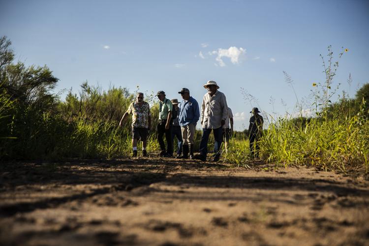
A group of scientists, community members and journalists walk through a channel leading to the Santa Cruz River on the Tohono O'odham Nation Wednesday, Sept. 18, 2019.
A look at the River
Tony Burrell, the tribal district council member, recently jointed two other district officials and three researchers and water experts, including author Johnson, on a visit to the river.
Normally, the river is closed to the public but the districtтs Natural Resources Department allowed the visitors to see what it looks like.
Three new streams have formed inside a riverbed up to 2,000 feet wide in this area. Two run relatively fast; the third runs slowly, creating marshy conditions. All are lined with tree seedlings, shoots and tall grasses.
A district official, Cieтna Schlaefli, noted that the river is already much richer and lusher with vegetation than it was when the water was first discovered a year ago.
In fall 2018, officials brought a drone to the river to take video shots, and тit was all bare, but the water was flowing,т said Schlaefli, a natural resource specialist for the district.
The Santa Cruz at San Xavier was first in line in the УлшжжБВЅ area to recover naturally, because itтs underlain by a thick layer of bedrock fairly close to the ground surface, said Robert Webb, a retired U.S. Geological Survey hydrologist, and Eric Holler, a retired U.S. Bureau of Reclamation engineer who has worked closely with the tribe on river management.
The groundwater here has always been shallow, with a basaltic dike forcing up the water, said Webb, another co-author of тRequiem for the Santa Cruz.т
Holler, who grew up in Nogales in the 1950s and т60s, recalled riding past the river with his father en route to УлшжжБВЅ when he was about 10, and noticing that mesquites, willows and cottonwoods were dying off.
тIтd ask my dad why, and he said, тthey were poisoning them, sucking too much water,тт Holler said. тItтs not a swimming pool down there in the aquifer т itтs more like a saturated sponge.т
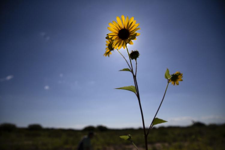
Today, Johnson and Webb repeatedly used words like тamazingт to describe plants like a 10-foot-tall sunflower, and purple aster blossoms atop tall plants.
Pointing to a gently running stream, Holler noted that the water is clear т тwith no smell. Itтs got algae, but itтs not overwhelmed by algae.т

A sunflower grows in a channel leading to the Santa Cruz River on the Tohono O'odham Nation Wednesday, Sept. 18, 2019.
For the future, some concerns
As for the future, тThereтs a whole bunch of irons in the fire right now,т Holler said. тNo one can tell me what the ultimate result will be.т
УлшжжБВЅ Water plans to increase pumping pressure in the area, by doubling the amount of groundwater it takes from its Santa Cruz well-field east of the river over the next decade.
The well-field lies directly north of the Pima Mine Road recharge basins and contains CAP water that was sunk into the basins. The pumping increase will significantly reduce flows from the recharge area into the riverтs aquifer.
At the same time, not all the impacts of rising water tables will be positive, Holler said.
On the Native American reservation, if water rises too high it could clog up the farm fields. Then, тyouтd have to put in a drain system like they do along the Colorado River near Yuma,т where groundwater levels are high, Holler said.
Tribal leadersт main concern today is that when the water resumed flowing last year, a lot of off-road vehicles started coming in. The vehicles left behind scars of tire tracks т still visible in the riverbed.
Because of concerns about trespassing, the district doesnтt plan to promote this river water as a tourist attraction, Burrell said.
Indeed, tribal leaders such as Nunez declined to talk publicly about the river water for some time, until it became clear that many passersby were aware of it. For now, said Burrell, тit will be left as it is.т
In УлшжжБВЅ, rising water levels in the river could someday leach pollutants out of long-abandoned landfills there into the Santa Cruz, Holler said.
УлшжжБВЅ Water Director Tim Thomure said thatтs unlikely, however. The depth of water in the river is unlikely to ever be high enough, he said, adding that one landfill has already been removed and the rest will either be cleaned up or removed over time.
Over the long haul, the biggest unknown is how long all this CAP water will be available to keep replenishing the Santa Cruz.
The Colorado River is expected to shrink over the coming decades because of climate change, although no one can say for sure how much. That would eventually trigger cuts in УлшжжБВЅтs CAP supply. The Colorado provides 40% of УлшжжБВЅтs water supply.
But for now, the Santa Cruz near San Xavier is a story about how importing water from a river 300 miles away is restoring another one, long left for dead.
тThe vision of our elders in the 1970s ... they envisioned seeing water running again down
the river, as one of the uses of that water. Our elders wanted to see the riverbanks restored as they once remembered it, full of mesquite and cottonwood and thriving with wildlife.т Julie Ramon Pierson, Tribal elder
30+ historic photos of the Santa Cruz River through УлшжжБВЅ

Waterfalls on the Santa Cruz River in 1889 near Sentinel Peak in УлшжжБВЅ.

Girls in Santa Cruz River,1889-1890.

A bridge over the Santa Cruz River near Sentinel Peak in УлшжжБВЅ washed out during flooding in 1915.

Santa Cruz River at St. Mary's Road bridge in 1931.

The Santa Cruz River flows north as seen from Sentinel Peak in УлшжжБВЅ in the early 1900's.

El Convento along the Santa Cruz River, ca. 1910.

Flooding of the Santa Cruz River, УлшжжБВЅ, in September, 1926, from тLetters from УлшжжБВЅ, 1925-1927т by Ethel Stiffler.

Flooding of the Santa Cruz River, УлшжжБВЅ, in September, 1926, from тLetters from УлшжжБВЅ, 1925-1927т by Ethel Stiffler.

Aerial view of the Santa Cruz River as it winds its way through Pima County north of Cortaro Road in 1953. The county was considering a bridge at several locations, but had to contend with the ever-changing course of the river.

The УлшжжБВЅ Citizen wrote in 1970, "The Santa Cruz River is a garbage dump" and "even marijuana grows in it." City leaders were pushing to upgrade and beautify the channel. The U.S. Army Corps of Engineers was studying the possibility.

The Santa Cruz River flowing under the Congress Street bridge in August, 1952. The Garden of Gesthemane is in the background.

By July 24, 1970 the old bridge on West Congress over the Santa Cruz River had to go and be replaced by a new bridge.

By July 24, 1970 the figures from Felix Lucero's Last Supper had been on the west side of the Santa Cruz River for more than 20 years. City authorities had decided to leave it in place while a new bridge on West Congress Street was to be replaced.

Volunteers from the УлшжжБВЅ Jaycees and Junior Chamber of Commerce finish restoration of the statues and grounds of the Garden of Gethsemane along the Santa Cruz River in May, 1964. The statues were ravaged by vandals and weather. The city parks and recreation department worked with the volunteers. Artist Felix Lucero began sculpture project in 1938 and finished it nine years later.

Drought in June, 1974, turned the Santa Cruz riverbed into crunchy chunks of dried mud.

The Santa Cruz River flowing under Silverlake Road in August, 1970.

Children play in the Santa Cruz River near Speedway Blvd in August, 1970.

The Santa Cruz riverbed at Congress Street in November, 1967.

After years of waiting, crews began clearing debris and channeling the Santa Cruz River in November, 1977, and constructing what would become a 14-mile river park. The Speedway Blvd. bridge is in the background.

After years of waiting, crews began clearing debris and channeling the Santa Cruz River in November, 1977, and constructing what would become a 14-mile river park.

The Santa Cruz River looks peaceful flowing underneath Speedway Road after days of flooding in October, 1977.

Adalberto Ballesteros rides along the Santa Cruz River west of downtown УлшжжБВЅ in 1980.

The Santa Cruz River looking north from Valencia Road in July, 1974.

Junked cars and trash spill into the Santa Cruz River, looking south, just south of Grant Road in July, 1974.

Road graders scrape the Santa Cruz River channel between Speedway and Grant roads during bank stabilization construction in May, 1991.

Water surges in the Santa Cruz River at the St. Maryтs Road bridge on Oct. 2, 1983.

Flooding in Marana after the Santa Cruz River overflowed its banks in Oct. 1983.

A bridge on the Santa Cruz River northwest of УлшжжБВЅ washed out during flooding in October 1983.

Residents watch the surging Santa Cruz River rush past West St. Mary's Road on January 19, 1993.Т

УлшжжБВЅ firefighters are standing by and waiting for two kids floating in the Santa Cruz River on some type of object during flooding in July, 1996.

As the УлшжжБВЅ Modern Streetcar rumbles across the Luis G. Gutierrez Bridge, water flows bank to bank along the Santa Cruz River after a morning monsoon storm on July 15, 2014.

Johnny Dearmore skips a rock in the Santa Cruz River as reclaimed water is released into the channel at 29th Street as part of the Santa Cruz River Heritage Project on June 24, 2019. The release of effluent is the cityтs first effort to restore a fraction of the riverтs flow since groundwater pumping dried it up in the 1940s.

The Santa Cruz River flows Friday morning July 23, 2021 after an overnight monsoon storm passed over in УлшжжБВЅ, Ariz.

Betsy Grube, center, with УлшжжБВЅ Game and Fish Department, releases longfin dace fish into the Santa Cruz River at Starr Pass Boulevard on March 23, 2022, as Mark Hart, right, takes a video and Michael Bogan, a professor in aquatic ecology at the University of УлшжжБВЅ, picks up more fish to release. The 600 fish were captured from Cienega Creek in Vail.


