

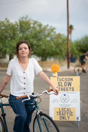
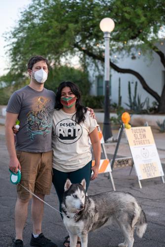
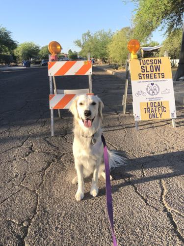
The УлшжжБВЅ Department of Transportation and Mobility says it is aiming to support residentsт well-being during the coronavirus pandemic through a new pilot program for neighborhood streets.
Through the Slow Streets initiative, roads are reconfigured to temporarily limit them to local traffic using barricades, cones and signs to make way for all people to safely spend time outdoors while social distancing.
The department is using the materials in hopes of encouraging drivers to use alternate routes, use caution when driving in the area and to only use designated тslow streetsт when necessary to reach a final destination, the department said.
Access for residents, emergency vehicles, environmental services and delivery vehicles are not blocked. The designated streets will not be placed in transit areas or commercial areas.
People are also reading…
Between May and June, the department deployed its low-cost materials to the Feldmanтs, Barrio Sin Nombre, and Fairgrounds neighborhoods on two-week rotations.
тWorking with the neighborhoods we identified low-cost traffic improvements that will now be implemented based on what we learned from the slow streets installation,т said Gabriela Barillas-Longoria, the departmentтs livability planner. тThe pilot phase was really successful. We received positive feedback and interest from the community.т
More than 50 applications had been sent in as of last week to be a part of Phase 2 of the initiative.
The department is looking to complete a minimum of 12 to 15 more street segments by December.
тThese (barriers) will be up a little longer, which is good because we know that behavior change takes some time,т she said, noting materials will appear in the neighborhoods for three to four weeks.
Three neighborhoods have been selected: Old Pascua, Miracle Manor and an unnamed area without an association near East 42nd Street and South Prudence.
One of the programтs goals is to prioritize underserved communities hit the hardest by pandemic.
Once a neighborhood is found, the department will find a neighborhood representative to engage residents within the community.
тWhat weтre doing is recruiting block leaders at each of the slow street locations т once we know where those are т to inform their neighbors and get feedback on the program. Theyтre going to also help inform the future street improvements,т said Barillas-Longoria, who created the position.
The leaders will receive a stipend as well as a shirt, lawn signs and flyers while assisting with planning, implementation, monitoring and evaluation of the neighborhood project.
Each position is funded through a grant from PeopleForBikes, a national nonprofit bicycling advocacy organization.
In the future, the department hopes to create neighborhood gathering spaces т once itтs safe to do so т and connect them to bike boulevards, which provide a low-stress biking network by using calmer residential streets as alternatives to major thoroughfares.
Barillas-Longoria said after the trial periods, тItтs going to be followed up with constructing temporary, low-cost traffic calming improvements, like traffic circles, chicanes, those kinds of things.т
тItтs going to be whatever the neighborhood wants. Itтs really a unique project because oftentimes transportation projects can take years, but beginning to end, itтs going to be about two months per location. Theyтll see some really quick improvements,т she said.
Down the Road
Lane restrictions for I-10 near Ruthrauff this week: Motorists on Interstate 10 and the westbound frontage road near Ruthrauff Road in УлшжжБВЅ should expect overnight lane restrictions this week due to underground work.
The following restrictions are planned each night from 9 p.m. to 5 a.m.:
- From Monday to Wednesday, both directions of I-10 will be reduced to a single lane in each direction between Prince and Sunset roads.
- On Thursday, the westbound frontage road will be reduced to a single lane between Ruthrauff and Sunset roads.
Drivers should use caution and watch for construction personnel and equipment.
Photos: Catalina Highway to Summerhaven opens after Bighorn Fire
Catalina Highway Reopens

Deymo Fernandez, left, and Sara Hernandez, look at a burn scar from the Bighorn Fire on the north side of Mount Lemmon outside the Iron Door Restaurant, 10300 E. Ski Run in Summerhaven on August 2, 2020.
Catalina Highway Reopens

The burn scar from the Bighorn Fire is shown on a portion of the north side of Mount Lemmon, as seen from the Mount Lemmon Fire Department, on Catalina Hwy. in the Santa Catalina Mountains in Ariz on August 2, 2020.
Catalina Highway Reopens

Lorena Navarro and her son Erick Navarro sit on a log inside a group of trees burnt by the Bighorn Fire near the Marshall Gulch trailhead in Summerhaven, Ariz on August 2, 2020. Coronado National Forest is closed to the public and authorities warn that forays into forest can be dangerous due to snags and debris.
Catalina Highway Reopens

Snags and charred brush remain on a section on the north side of Mount Lemmon, as seen from the Mount Lemmon Fire department, on Catalina Hwy. in the Santa Catalina Mountains in Ariz on August 2, 2020.
Catalina Highway Reopens

David Dynes and Marylyn PiУБa sit in some shade near burnt trees on E. Ski Run, in Summerhaven, Ariz on August 2, 2020.
Catalina Highway Reopens

A vehicle drives past a burnt tree in front of Incinerator Ridge on Catalina Hwy. in the Santa Catalina Mountains in on August 2, 2020.
Catalina Highway Reopens

To escape the heat, a family hangouts near Marshall Gulch trailhead in Summerhaven, Ariz on August 2, 2020. Coronado National Forest is closed, so people trying to escape the heat should make sure check with authorities before picnicking. Many areas of the forest are dangerous due to snags and debris in the wake of the Bighorn Fire.
Catalina Highway Reopens

A pine cone with ash stuck to sap rests on the floor near the Marshall Gulch trailhead in Summerhaven, Ariz on August 2, 2020.
Catalina Highway Reopens

Peggy Price takes a picture of a burn scar from the Bighorn Fire on the north side of Mount Lemmon outside the Iron Door Restaurant, 10300 E. Ski Run, Summerhaven, on August 2, 2020.
Catalina Highway Reopens

A truck drives up the Catalina Highway approaching Windy Vista Point, on Aug. 1, 2020. The Catalina Highway to Summerhaven opened to the general public Saturday morning for the first time since its closure due to the Bighorn Fire. The Coronado National Forest surrounding the highway still remains closed.
Catalina Highway Reopens

Vehicles drive up Catalina Highway near Geology Vista Point, on Aug. 1, 2020. The Catalina Highway to Summerhaven opened to the general public Saturday morning for the first time since its closure due to the Bighorn Fire. The Coronado National Forest surrounding the highway still remains closed.
Catalina Highway Reopens

A burned section of the Catalina Mountains seen near Aspen Vista Point, on Aug. 1, 2020. The Catalina Highway to Summerhaven opened to the general public Saturday morning for the first time since its closure due to the Bighorn Fire. The Coronado National Forest surrounding the highway still remains closed.
Catalina Highway Reopens

A burnt out hilltop near the Mount Lemmon helicopter pad, on Aug. 1, 2020. The Catalina Highway to Summerhaven opened to the general public Saturday morning for the first time since its closure due to the Bighorn Fire. The Coronado National Forest surrounding the highway still remains closed.
Catalina Highway Reopens

People look at a burn scar in an area below the Mount Lemmon Ski Valley, on Aug. 1, 2020. The Catalina Highway to Summerhaven opened to the general public Saturday morning for the first time since its closure due to the Bighorn Fire. The Coronado National Forest surrounding the highway still remains closed.
Catalina Highway Reopens

A burned section of the Catalina Mountains seen near Aspen Vista Point, on Aug. 1, 2020. The Catalina Highway to Summerhaven opened to the general public Saturday morning for the first time since its closure due to the Bighorn Fire. The Coronado National Forest surrounding the highway still remains closed.
Catalina Highway Reopens

Road closure below the Mount Lemmon Summit Trailheads, on Aug. 1, 2020. The Catalina Highway to Summerhaven opened to the general public Saturday morning for the first time since its closure due to the Bighorn Fire. The Coronado National Forest surrounding the highway still remains closed.
Catalina Highway Reopens

A burn scar near the Mount Lemmon Ski Valley, on Aug. 1, 2020. The Catalina Highway to Summerhaven opened to the general public Saturday morning for the first time since its closure due to the Bighorn Fire. The Coronado National Forest surrounding the highway still remains closed.
Catalina Highway Reopens

Road closure below the Mount Lemmon Summit Trailheads, on Aug. 1, 2020. The Catalina Highway to Summerhaven opened to the general public Saturday morning for the first time since its closure due to the Bighorn Fire. The Coronado National Forest surrounding the highway still remains closed.
Catalina Highway Reopens

A burn scare seen from the Mount Lemmon Ski Valley, on Aug. 1, 2020. The Catalina Highway to Summerhaven opened to the general public Saturday morning for the first time since its closure due to the Bighorn Fire. The Coronado National Forest surrounding the highway still remains closed.
Catalina Highway Reopens

A burned section of the Catalina Mountains seen near Aspen Vista Point, on Aug. 1, 2020. The Catalina Highway to Summerhaven opened to the general public Saturday morning for the first time since its closure due to the Bighorn Fire. The Coronado National Forest surrounding the highway still remains closed.
Catalina Highway Reopens

A burn area can be seen northwest of Summerhaven, on Aug. 1, 2020. The Catalina Highway to Summerhaven opened to the general public Saturday morning for the first time since its closure due to the Bighorn Fire. The Coronado National Forest surrounding the highway still remains closed.
Catalina Highway Reopens

A burnt hillside near cabins in Summerhaven, on Aug. 1, 2020. The Catalina Highway to Summerhaven opened to the general public Saturday morning for the first time since its closure due to the Bighorn Fire. The Coronado National Forest surrounding the highway still remains closed.
Catalina Highway Reopens

Charred ground from the Bighorn Fire seen near the Marshal Gulch Trailhead, on Aug. 1, 2020. The Catalina Highway to Summerhaven opened to the general public Saturday morning for the first time since its closure due to the Bighorn Fire. The Coronado National Forest surrounding the highway still remains closed.
Catalina Highway Reopens

Vehicles drive through Summerhaven, on Aug. 1, 2020. The Catalina Highway to Summerhaven opened to the general public Saturday morning for the first time since its closure due to the Bighorn Fire. The Coronado National Forest surrounding the highway still remains closed.
Catalina Highway Reopens

A burned section of the Catalina Mountains seen near Aspen Vista Point, on Aug. 1, 2020. The Catalina Highway to Summerhaven opened to the general public Saturday morning for the first time since its closure due to the Bighorn Fire. The Coronado National Forest surrounding the highway still remains closed.
Catalina Highway Reopens

Vehicles drive up the Catalina Highway approaching Windy Vista Point, on Aug. 1, 2020. The Catalina Highway to Summerhaven opened to the general public Saturday morning for the first time since its closure due to the Bighorn Fire. The Coronado National Forest surrounding the highway still remains closed.
Contact Star reporter Shaq Davis at 573-4218 or sdavis@tucson.com. On Twitter: @ShaqDavis1

Shaq Davis
Reporter


