

УлшжжБВЅ transportation officials are collaborating with out-of-state officials to make sure long-haul truckers stay in tip-top shape.

The latest updates related to COVID-19 in УлшжжБВЅ and Southern УлшжжБВЅ.Ь§
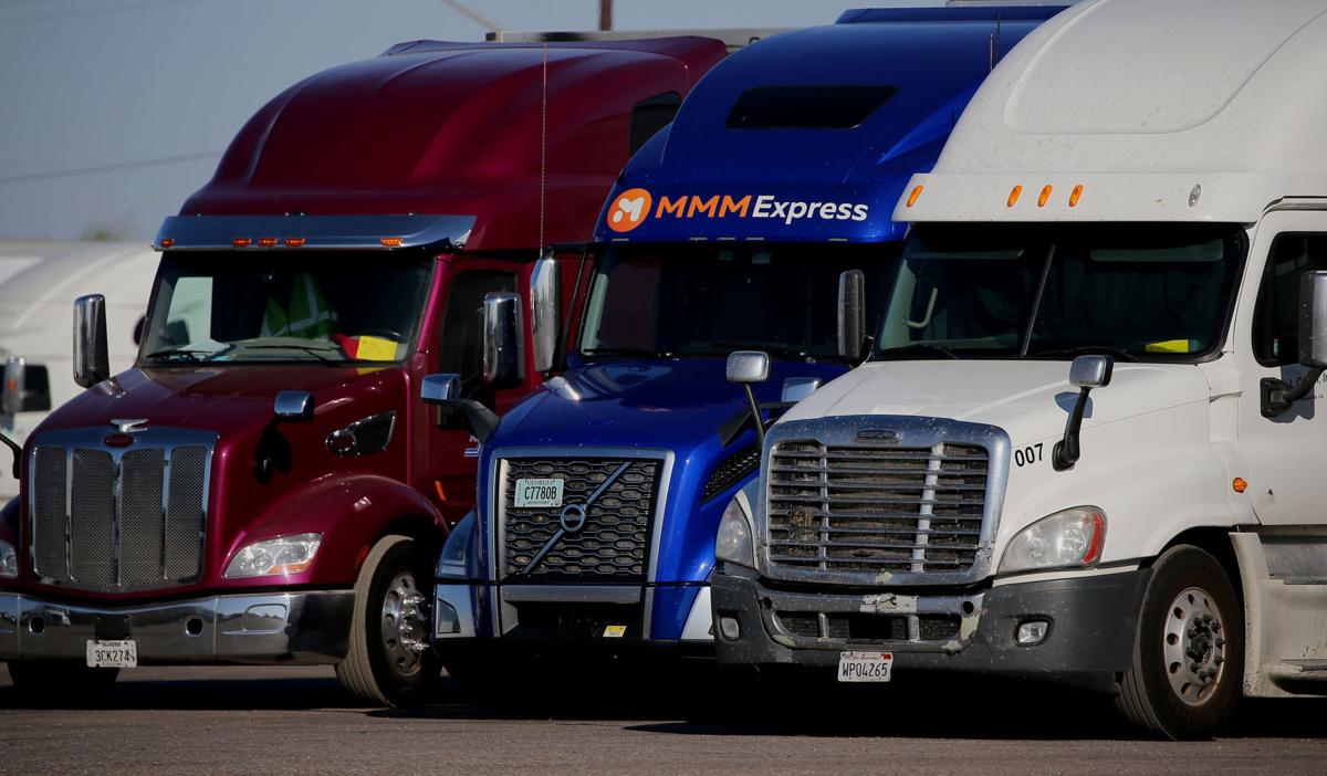
The УлшжжБВЅ Department of Transportation is building a truck parking availability system, along with California, New Mexico and Texas. The goal: preventing long-haul drivers from putting themselves in dangerous situations when needing to stop for a rest along Interstate 10.
тTruck drivers along this corridor frequently have difficulty finding authorized parking, which can result in decisions to park in unauthorized or unsafe locations, such as along highway shoulders, or to continue driving beyond hours-of-service limits,т project officials said. тThis will reduce the amount of time and fuel spent looking for parking.т
Officials say they will implement a technology that тdetects, monitors and providesт real-time truck parking availability using тroadside dynamic message signs, smartphone and in-cab applications and online via websites and traveler information sites.т
People are also reading…
Once online, the system will track available truck parking at 37 public rest areas and 550 parking spaces throughout the four states, which make up the I-10 Corridor Coalition.
It will be done, in part, with use of a $6.85 million grant awarded in April 2019 from the U.S. Department of Transportationтs тAdvanced Transportation and Congestion Management Technologies Deployment.т
The I-10 Corridor Coalition have also agreed to match those federal funds, bringing the total project funding to $13.7 million.
The projectтs launch is anticipated for 2023.
тThis system will provide real-time truck parking information to assist truck drivers and dispatchers in making informed parking decisions, and improve safety, mobility, operational and environmental elements,т ADOT said.
Included in УлшжжБВЅ officialsт efforts is input from trucking industry advocates, such as the УлшжжБВЅ Trucking Association, to determine тbest practices and find features that would be beneficial for drivers, all the way down to the design of the signт said Tony Bradley, the organizationтs president and CEO.
He said the organization has been working for the past two years with ADOT to address truck parking issues and determine the systemтs most beneficial elements.
тOne of the questions is how close to the facility do you notify people of truck parking spots. Obviously, as people are driving from point A to point B, theyтre trying to plan where they can take a rest,т Bradley said. тReally, itтs what information will allow that driver to determine whether they should pull off at the next rest area, or the next rest area, some of itтs just spacing of when the notification happens.т
In addition to those spatial notifications for drivers, the corridor coalition will determine the key information dispersed to truckers to ensure they have the best chance of obtaining a spot to rest.
тAnother feature is determining whether or not to actually list the number of spaces available. Because obviously, that changes in real time, or if you simply do an тalmost fullт notification, versus тtwo spots leftт, because thereтs a very real chance that driver may see two spots left and by the time they get to that facility, the two spots are full,т Bradley said.
Ahead of any final decisions, the coalition is asking for stakeholdersт input through a survey running until Oct. 30. Interested members should visit .
тWe are encouraged by the progress,т said Bradley about the project. тWe like the fact that it is a multi-state collaboration. It involves a heavily trafficked corridor, so weтre looking at a holistic approach as opposed to a patchwork approach.т
Down the Road
Railroad work will affect traffic in Sahuarita: Drivers in Sahuarita should expect significant delays, possibly up to an hour for some motorists, due to urgent maintenance along the Union Pacific Railroad.
Tracks will be reset on the crossing nearest to Sahuarita Road and Nogales Highway completely closing the road from 5 a.m. Wednesday to 7 p.m. Thursday.
Sahuarita Road will be closed from Azatlan Avenue to Nogales Highway. Westbound traffic will be able to U-turn at Azatlan. Eastbound traffic will be able to turn left or right onto Nogales Highway.
For westbound drivers, an available detour is North Wilmot Road to West Valencia Road onto South Nogales Highway.
Eastbound travelers can use North Nogales Highway to East Valencia Road onto South Wilmot Road.
Today in history: Oct. 5
Apple founder Steve Jobs, 56, died in Palo Alto, California, and more events that happened on this day in history.
Stories behind 11 УлшжжБВЅ-area street names:
The stories behind 11 УлшжжБВЅ-area street names
Craycroft Road

Southbound traffic proceeds along North Craycroft Road, south of East Speedway Boulevard in УлшжжБВЅ on April 25, 2017. Craycroft is one of the majors roads being considered for improvement if the voters approve the measure next month during a Special Election on May 16.
Frank Craycroft, a mechanical and mining engineer, built one of the most impressive houses of the day on the road that now bears his name.
Craycroft was born in Louisville, Ky., in 1872, to Elkanah and Louise Craycroft. He graduated from the University of Kentucky and then, following in the tradition of men in his family, enrolled in the University of Edinburgh in Scotland. On graduation day in 1889, he received his degree in mining engineering and also became a CPA.
He spent the next four years working with his father on water works projects. After his father died, he lived in Boulder, Colo., Bisbee, Globe and Los Angeles. He also served in the Spanish-American War in 1898.
In 1904, Craycroft came to УлшжжБВЅ, working mostly in heating and power plant construction. He also was chief engineer for the J. Knox Corbett Co., and later went into business for himself. The 1925 УлшжжБВЅ City Directory lists his business, Frank Craycroft Plumbing and Heating, at 40 Toole Ave., downtown.
He was also an important promoter of the El Conquistador Hotel, where El Con Mall is now.
Craycroft was married twice, first to Mary L. Norman, of Texas, who died in 1917, and again in 1925 to Edna E. Huckabee (some sources site her last name as Greene). He had three children.
In 1925, he built a house in the desert, just off a dirt road that was then called Kenyon. A УлшжжБВЅ Citizen article in May of that year described the house as "of Spanish architecture and is built in the shape of an 'H.'
" The article said it "contains nine rooms and three baths . . . two large sleeping porches, and a porch built on the roof, which is gained by means of a spiral stairway."
The house, at 5524 E. Fourth St., off Craycroft Road, has been remodeled and changed hands several times. In the 1990s, it was the headquarters of the
УлшжжБВЅ chapter of the American Cancer Society. It is now a private business.
Roughly 15 years after the house was built, Kenyon Road was renamed Craycroft Road.
Frank Craycroft died suddenly on May 10, 1929, at his home. He was 56 years old.
Kino Parkway

Father Eusebio Francisco Kino rides in perpetuity at 15th Street and Kino Parkway, and in Magdalena de Kino, Sonora, and Segno, Italy.
Eusebio Francisco Kino, the father of УлшжжБВЅ's San Xavier Mission, is the namesake for Kino Parkway, which runs from East Broadway south to Benson Highway.
Kino, whose nickname became "The Apostle of УлшжжБВЅ," was born in 1645 in the town of Segno, Italy. He excelled in cartography, mathematics and astronomy.
As a teenager, he fell seriously ill and vowed to St. Francis Xavier that if God would save him he would become a missionary to the Orient. Entering the priesthood in 1665, he spent a dozen years studying to become a Jesuit priest.
At age 36, in 1681, he arrived in Mexico, and the following year, he mapped out Baja California and the Sea of Cortez. Later he became the first person to confirm that California was not an island, as was a common belief at that time.
His 1706 map of Southern УлшжжБВЅ was so accurate that it went unaltered for a century.
In 1691, Kino embarked on the initial expedition into the Pimeria Alta, land of the Upper Pimas, in northern Sonora and Southern УлшжжБВЅ; he would make a total of nine trips to УлшжжБВЅ. He followed the Santa Cruz River north and stopped by what became the Tumacacori Mission. On his second mission about a year later, he visited the village of Bac, south of УлшжжБВЅ, where he laid the foundation for the San Xavier Mission. It was built after his death and is still active today.
At Bac and Schookson, he counted 900 and 800 Indians, respectively; the Spanish incorrectly pronouncing Schookson as УлшжжБВЅ, which translates roughly to "at the foot of the black hill." The Indians were living in clusters of houses along the banks of the Santa Cruz River.
Kino spent 20 years in the Pimeria Alta and established 24 missions. He trained natives as cowboys - the roots of the cattle industry in the Southwest stem from the rancho missions he started in УлшжжБВЅ.
He also earned the respect of his fellow missionaries and the Indians with whom he worked. He was known for his compassion and his hard work.
Kino died at Magdalena, Sonora., in 1711 at 65.
Egleston Drive

Egleston Memorial Drive and Egelston Drive, both in Oro Valley, are named in honor of landowners who helped preserve some of УлшжжБВЅ's most scenic land.
Charles Egleston was born in 1895 in Westfield, Mass., and his wife, Anna (Kehr) Egleston, was born three years later in 1898 in New York City. The two arrived in УлшжжБВЅ in the 1920s with their two children - three others later would be born in УлшжжБВЅ. Before moving to УлшжжБВЅ, Charles had served in the U.S. Navy.
When they first moved to УлшжжБВЅ, the Eglestons lived near East Glenn Street and North First Avenue, and Charles worked as a self-employed electrician. In the 1930s, they purchased large tracts of land around УлшжжБВЅ, including 65 acres near Pusch Ridge, which was their largest holding. It was bounded by Oracle Road on the west, Linda Vista Boulevard on the north, and Calle Concordia on the south and also included two parcels totaling 30 acres on the west side of Oracle Road north of Calle Concordia.
Part of that land is now the James Kriegh Park, which sits next to Egleston Drive. On one of these two parcels they built the family home, which was finished in 1951 and still exists today at 9465 N. Oracle Road.
Outside of work, the Eglestons volunteered with the Beacon Group, a non-profit organization dedicated to supporting and providing opportunities for individuals with developmental disabilities. Charles died in 1965, but Anna lived until her 99th birthday. Throughout her life she was dedicated to her Christian faith, including her mission work on the Indian reservations throughout УлшжжБВЅ.
Perhaps the couple's greatest legacy was preserving the land on North Oracle where Pusch Ridge Christian Academy and Canyon del Oro Baptist Church are now located. They gave the land to the Palo Verde Baptist Church in 1958, with the stipulation that it be used "for religious and educational purposes only."
The road in the Pusch Ridge property is named Egleston Memorial Drive, in honor of Charles and Anna.
Bentley Avenue

Bentley Avenue was named not for the famed automobile, but for a УлшжжБВЅ family whose most prominent member helped improve education and health-care opportunities for the area's poorest residents.
Evalyn Bentley was born in Friend, Neb., in 1878. Her parents, Randall and Sarah Bentley, of Canada, had five children together. After Randall Bentley died, the family moved to УлшжжБВЅ in 1914.
That same year, Evalyn Bentley traveled by horseback to the Hopi Indian Reservation to assist in the development and improvement of the nation. She served as a field nurse, home economist, lawyer and doctor for the Hopi families.
She later became a home demonstration agent for Pima County, and in this role she organized programs that aided families with cooking, sewing and other items related to home management in rural УлшжжБВЅ. She also established a 4-H club.
Bentley paved the way for better education, health, and home life for Southern УлшжжБВЅ by introducing health and homemaking programs for rural housewives, and propelling Pima's first adult extension classes. One of the programs she introduced to the county, the "Keep Growing Project," offered free medical and dental services in rural areas and county schools.
The program was such a success that it later became part of the Pima County Health Center.
In 1947, Bentley retired from her home demonstration work in Pima County. She worked as Pima's home demonstration agent for 26 years and received honorable mention for her achievements at the First Presbyterian Church.
In 1960, while crossing Speedway on her way to church, Bentley and a friend were struck and killed by a car; she was 82 years old.
Bentley Avenue runs north-south between North УлшжжБВЅ Boulevard and North Country Club Road and between East Pima Street and East Grant Road.
The street was named after the family, which owned land west of Country Club Road.
Mabel Bentley, who was Evalyn's sister, married a member of the Stewart family, and that is where the name of the street next to it came from.
Ь§
Brichta Drive

Augustus C. Brichta was such a strong advocate of education that he worked two months without pay as the area's first school sputtered and then closed.
But his educational legacy lives on in the Augustus Brichta Elementary School, 2110 W. Brichta Drive, and the street named in his honor off North Silverbell Road and West Speedway.
Brichta was born in New York City on Sept. 2, 1821, to Francis and Amelia (Rudolphus) Brichta, who were from Germany. He was one of four children and was educated at the Jesuit College in Havana, Cuba, and at St. Louis University.
After finishing school he went to work with his father in Nacogdoches County, Texas. When the Mexican-American War began, he enlisted and served in the Second Mounted Volunteers under Gen. Zachary Taylor.
In 1846 and 1847 he was on the front lines and fought in the Battle of Monterrey. Many years later, he was a member of the Society of Mexican Veterans, which he had joined in San Francisco.
In 1849, Brichta traveled to California during the Gold Rush, mining for the precious metal on the American, Feather, and Yuba rivers, but found slim pickings.
He arrived in УлшжжБВЅ around 1864, and worked as a clerk for the First УлшжжБВЅ Territorial Legislature.
His next stop was УлшжжБВЅ, where he taught in the first English-speaking school. Held in an adobe building downtown, in 1868 it had about 55 students, all boys.
It had dirt floors, and the only furniture was pine benches and desks.
Due to lack of funding by the town, the school closed less than six months after opening, and Brichta taught the last two months without pay.
After that, Brichta worked for the firm Lord & Williams and did a stint as deputy postmaster.
He was Pima County Recorder for one term and also the first Justice of the Peace of Nogales.
Mining was his major endeavor throughout his life, and he worked three copper claims in the УлшжжБВЅ Mountains.
In 1872 Brichta wed Maria Jesusita Franco of Santa Cruz, Mexico, and adopted her three children. He died Dec. 21, 1910.
Samaniego Avenue
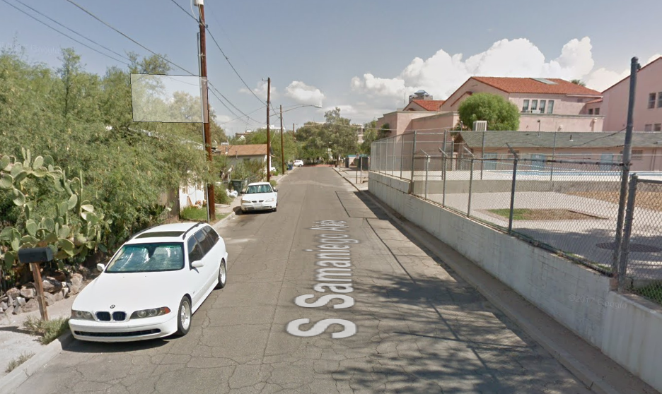
Samaniego Avenue, located south of the УлшжжБВЅ Convention Center downtown, is named in honor of a naturalized U.S. citizen who became one of the most powerful men in early УлшжжБВЅ.
Mariano Guadalupe Samaniego was born in Sonora, Mexico, in 1844. His parents, Bartolo and Ysabel Samaniego, were born there also.
Ysabel's father, Pedro Luna, was a soldier from Sonora; Bartolo's father, Tiburcio Samaniego, was a large land owner, magistrate and adviser and friend to the Opata and Yaqui Indians. His family was one of the oldest in Sonora.
After Bartolo's death in Mexico in 1850, Ysabel moved to what is now Mesilla, N.M., where she and Mariano ran a store. A few years later they became naturalized as a result of the Gadsden Purchase.
Mariano Samaniego attended St. Louis University, graduating in 1862. Next he signed on as an interpreter for the Confederate Army. In 1864, he began freighting supplies to and from multiple posts, traveling as far east as the Missouri River.
After marrying Dolores Aguirre in Las Cruces, N.M., he came to УлшжжБВЅ in 1869, and was awarded numerous contracts to carry supplies to various УлшжжБВЅ forts.
In 1881, after the murder of his brother Bartolo Jr. in an ambush by Apaches, he sold his contracts and started raising cattle, which he continued until his death. He also owned a large amount of real estate, including the Canyon del Oro and Rillito ranches, both north of УлшжжБВЅ.
The Canyon del Oro ranch is now the site of Biosphere 2.
Mariano Samaniego served as a УлшжжБВЅ city councilman, Pima County assessor, chairman of the Pima County Board of Supervisors and representative in the УлшжжБВЅ Territorial Assembly.
He also was on the University of УлшжжБВЅ's first board of regents and served two terms as president of the УлшжжБВЅ Historical Society.
During the last decade of the 1800s, when he was at the apex of his career, he was one of the most powerful men in УлшжжБВЅ. He died in 1907, at the age of 65.
Note: Samaniego's house, built in 1876, is at 222 S. Church Ave., south of La Placita Village.
Herbert Avenue
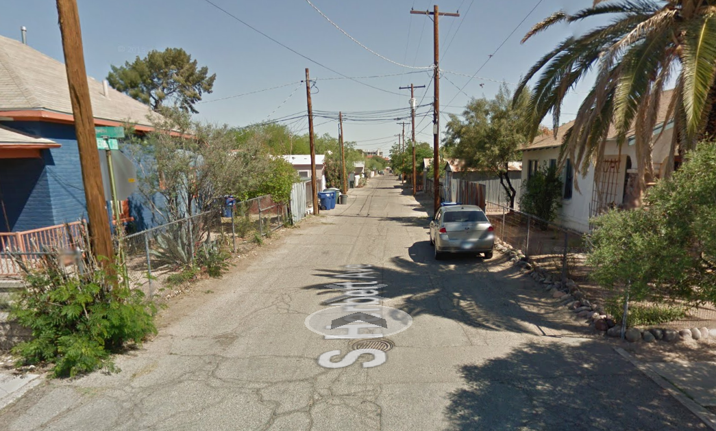
Herbert Drachman was born in 1876 in УлшжжБВЅ to Samuel and Jennie Drachman at a time when the Old Pueblo was still part of the Old West.
He grew up with his cousin Harry УлшжжБВЅ Drachman, who is said to be the first Anglo born in УлшжжБВЅ.
Toward the end of the 1800s, Herbert journeyed by stagecoach to Berkeley, Calif., where he studied at the University of California for five years. After graduating, he returned home and worked in his father's cigar store downtown. He also became active in athletics, with a particular fondness for baseball.
In 1909, after 10 years of business and civic duty, he went to San Francisco and founded a curio shop.
After the death of his father, he returned home in 1916 and set up a real estate and insurance company in which he flourished and was active until his death in the spring of 1937. He was married to Eda Drachman and had a stepson, Richard Drachman, who worked with him in his real estate and insurance business.
In 1934, he spearheaded a campaign to save the Orndorff Hotel downtown, but the landmark fell the following year to make room for a parking lot.
He spent more than two decades aiding the УлшжжБВЅ Chinese colony, the Yaqui Indians of Pascua Village and in many other civic activities.
He also advocated against attempts to legalize gambling but seemed most proud of being a member of УлшжжБВЅ's first volunteer fire department - he often showed off pictures of himself and other firefighters.
According to a file at the УлшжжБВЅ Historical Society, his father purchased the block between Broadway, Fifth Avenue and Ochoa Street for $48 around 1880 and named the street to the east Herbert Avenue after his son.
Blacklidge Drive

Frank E. Blacklidge Sr., the namesake of a street in central УлшжжБВЅ between Fort Lowell Road and Glenn Street, was an early contractor who was also a celebrated rancher and cook.
Blacklidge was born in Redondo Beach, Calif., on Nov. 15, 1888. In 1890 or 1891, he arrived in Benson with his family.
His parents divorced in 1892, and his mother, Laura (Trask) Blacklidge, gained custody of Frank, his brother, Harry J., and his sister, Myrtle.
He spent much of his childhood on his grandfather Jacob Trask's ranch. At about 10 years old, he roped his first steer while riding an old horse named Baldy. This experience came in handy later on when he worked as a cowhand for Jim Cummings on his Circle Five Ranch close to PeУБa Blanca Lake.
In 1912, the year УлшжжБВЅ gained statehood, Blacklidge was living in Patagonia, which was then so small that its jail was a "grilled iron door" at the entrance to a small mine just south of town. Blacklidge was one of the first people to enjoy the new jail, after a night of drinking with a cowboy friend, while driving a Model T.
In 1921 he arrived in УлшжжБВЅ, where he established a contracting company. Business was slow during the Great Depression, so he ran the O-J Ranch south of Three Points, off the road to Sasabe.
Blacklidge, whose nickname was "Pancho," loved to cook and reminisced in a 1966 УлшжжБВЅ article about a Fourth of July celebration at the ranch, where neighboring families barbecued, drank moonshine and danced to a fiddle and guitar. Some of his recipes were even published in Sunset magazine and a few cookbooks.
In the 1920s, Blacklidge built many of the homes on what is now Blacklidge Drive. This street was first recorded in the county records in 1922 and was one block long, between Cherry and Campbell avenues.
He owned a little ranch at 4200 E. Glenn St., just west of Columbus Boulevard.
He was married twice, first to Eleanor (Roberts) Blacklidge of Tombstone, with whom he had two children: Frank E. Blacklidge Jr. in 1926 and Ruth Marie Blacklidge in 1925. After Eleanor died in 1927, he married Augusta Frances (Haller) Blacklidge, who helped raise the kids.
Blacklidge died in 1973 in УлшжжБВЅ at the age of 84.
Runway Drive

Runway Drive, as the name suggests, was a runway at the old Gilpin Airport.
In the late 1930s, Walter Douglas Jr., a longtime pilot and flight instructor at the Davis-Monthan Airfield, purchased farmland northwest of УлшжжБВЅ. The area, near West Prince and North Romero roads, was leveled in 1939 by Fred Grissom, who became Douglas' chief mechanic.
A control tower, which was built on top of the passenger terminal, was built later, surrounded by hangars to the north and south. These structures exist today as part of the R.E. Darling Co., west of Romero Road.
Farming next to the airport continued for a few years. Douglas operated Gilpin Airlines as well as a flight school, which trained members of the University of УлшжжБВЅ's Reserve Officer Training Corps, among others.
In the late 1940s and early 1950s, Gilpin Speedway, an unpaved race track, drew crowds to watch midget-car and jalopy races.
In 1957, the airport was renamed the Central Airpark, and in 1958, under new ownership, it was rechristened Freeway Airport.
Thomas R. Borst purchased the 42-acre airport and several buildings in 1970. The airport went under in 1978. The land now is an industrial park, which includes the 25-acre Sun Tran Northwest Bus Facility.
Runway Drive is about a block east of Interstate 10, north of Prince. It runs parallel to the interstate.
Gates Pass
Thomas Gates came to УлшжжБВЅ in 1866 with Billy Brannen, a fellow poker player.
The two made money hand over fist in УлшжжБВЅ, Las Cruces, N.M., and Santa Fe, where the partnership ended in 1867.
Gates was born in Mount Pleasant, Canada, in 1834. Indian Territory (now Oklahoma) was the family's next stop, and then on to California.
After parting ways with Brannen, Gates returned to California by way of Salt Lake City. He made several visits to УлшжжБВЅ in the following years, and sometime in the 1870s he was married in Los Angeles and brought his wife to УлшжжБВЅ.
He became partners with territorial legislator Albert Franklin Banta for some time and later invested in mining.
In 1883, he acted as a lobbyist and helped repeal the bullion tax law. That same year he was head of the Democratic Territorial Central Committee. He was also a founding member of the УлшжжБВЅ Pioneers Historical Association and spent some time as a saloonkeeper.
He was appointed superintendent of the Yuma Prison by Gov. C. Meyer Zulick. In 1887, during a prison riot, he was stabbed in the neck and back. The trauma would haunt him for nearly a decade and eventually led to his suicide at the prison hospital.
Author William Ascarza wrote: "It was his legacy to discover the path through the УлшжжБВЅ Mountains, now called Gates Pass. Gates' objective was to establish a faster route between the Waterman Mountains in Avra Valley to the city of УлшжжБВЅ.
"Gates owned a profitable claim in the Waterman Mountains known as the Abbie Waterman Mine, which was 33 miles southwest of УлшжжБВЅ. It was to his economic advantage to find a shorter trade route to his carbonate mine. He discovered such a route via 'a natural canyon' that was 3,500 feet in height and a little over a mile long.
"Unfortunately, the УлшжжБВЅ Board of Supervisors failed to appropriate the necessary funding to build a road. Thomas Gates determined it a necessity and funded the project out of his own pocket. The total cost was $1,000. The result was the completion of a dirt road that directly linked УлшжжБВЅ with Avra Valley and shortened Gates' travel route from УлшжжБВЅ to the Waterman Mountains by eight miles."
Plumer Avenue
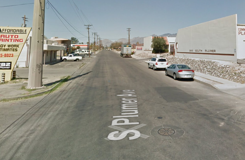
Plumer Avenue, between Campbell Avenue and УлшжжБВЅ Boulevard, is named in honor of a banker who helped УлшжжБВЅ grow and develop.
Nathaniel E. Plumer was born in 1866 in Detroit to Nathaniel B. and Martha (Sanborn) Plumer but grew up in Boston.
Plumer's first job was as a representative with the George H. Hammond Packing Co. After several years, he went into business for himself in the same field.
He arrived in УлшжжБВЅ in 1899, coming from Denver in a wagon due to health issues. Here he created a partnership with Fred J. Steward and was involved in real estate and insurance for three years as a member of the firm Plumer & Steward. Their offices were at 32 N. Stone Ave., where the Steinfeld Department Store would later stand.
With Steward and other investors, Plumer organized the Southern УлшжжБВЅ Bank & Trust Co. in 1903 and was elected president of the corporation - a role he would hold until his death. The bank was one of the strongest in the state, and in 1913 it had resources of more than $1 million.
Plumer was deeply involved in the creation of the УлшжжБВЅ YMCA. He became president of the board of trustees and guided the construction of the headquarters and purchase of equipment.
He also was active in the prohibition of alcohol and gambling in УлшжжБВЅ.
He owned property near the University of УлшжжБВЅ -likely in the area bounded by East Speedway, North Campbell Avenue, East Elm Street and North УлшжжБВЅ Boulevard - which he organized into a subdivision. He loved to play desert golf on the land, and also to race cars down Speedway.
Plumer married Mabel Roberts of New England, and they had one daughter, Alice Plumer.
After a visit to his summer home in Oracle, he became ill and died in 1917.
Contact Star reporter Shaq Davis at 573-4218 or sdavis@tucson.com
On Twitter: @ShaqDavis1

Shaq Davis
Reporter


