The Federal Aviation Administration decided not to prosecute a person suspected of flying a drone illegally into Bighorn Fire-fighting airspace because it couldnтt prove he or she was the pilot, a spokesman said this week.
The decision illustrates the difficulties in proving identities of those who remotely operate unmanned drones. And the lack of prosecution frustrates both a University of УлшжжБВЅ official involved in studying the wildfire and a private drone operator. While not criticizing the FAA, they said that when a drone operator gets away with illegal behavior,it will embolden others to follow the same course.
тI get that itтs hard (to prove). Some effort should be put into technology to identify the individuals that are invading this airspace at critical times,т said Ben Wilder, director of UAтs Tumamoc Hill Desert Laboratory and an executive producer of a recent webinar series on the Bighorn Fire. тBecause itтs proven that if the Forest Service canтt get at their assets at that moment, then the fire gets an upper hand on them. Itтs all so time sensitive.т
People are also reading…
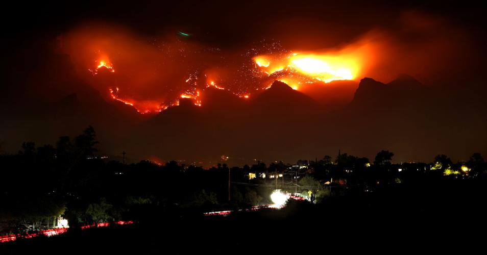
The presence of at least two drones in the Pusch Ridge area forced firefighters to suspend aerial operations at a crucial stage in the Bighorn Fire in early June on at least two occasions, Forest Service officials said at the time. Those suspensions slowed the serviceтs ability to battle the blaze just as it was getting underway, authorities have said.
The fire started on about 200 acres on June 5 but spread to 2,500 acres by June 8 after two drone incursions occurred, Forest Service officials said at the time. The blaze burned 120,000 acres in the Catalina Mountains by the time the Forest Service declared it fully contained on July 23.
тWe conducted a thorough investigation into this incident. However, we were not able to conclusively determine that the suspected drone operator was the pilotт who violated FAA flight restrictions in the wildfire area, FAA spokesman Ian Gregor said Thursday in an email to the Star.
тThat said, we did counsel the drone pilot, both orally and in writing, about the importance of not flying drones near wildfires and observing any (flight restrictions) that are in place,т he said.
The agency declined to provide the personтs name or gender because it didnтt prosecute.
Gregor declined to elaborate on why the FAA couldnтt prove the drone operator it investigated and interviewed was the one involved in the airspace intrusion.
The aircraft was licensed with the FAA, as legally required, he said.

The presence of at least two drones in the Pusch Ridge area forced firefighters to suspend aerial operations at a crucial stage in the Bighorn Fire in early June on at least two occasions, Forest Service officials said at the time.
тSpeaking generally, the more concrete evidence we have, the easier it is to put together an enforcement case. Concrete evidence can include photos, videos, eyewitness reports, an admission by a pilot, and data and other records,т Gregor said.
The FAA didnтt specify a date on which this drone violation occurred. But the Forest Service issued news releases saying that two such incidents occurred on June 5 т the day the fire was sparked by lightning т and on June 8, a day in which the fire was spreading rapidly.
KVOA-TV reported at the time that a third illegal drone overflight occurred around then. The Forest Service seized two drone aircraft and the cases were referred to the FAA and FBI, the TV station reported.
One drone case was turned over to the Forest Serviceтs law enforcement office, Coronado National Forest Supervisor Kerwin Dewberry told the Star on Thursday. The serviceтs public information staff didnтt respond to requests from the Star for more information on that investigation. Previously, two national forest spokeswomen had said drone-related cases had been turned over to the FBI.
Brooke Brennan, an FBI spokeswoman in Phoenix, would not comment on the drone case, saying, тAs a matter of course, the FBI does not confirm or deny the existence of an investigation.т
Dewberry said one drone craft burned up in the wildfire but that he didnтt know what happened to the second one.
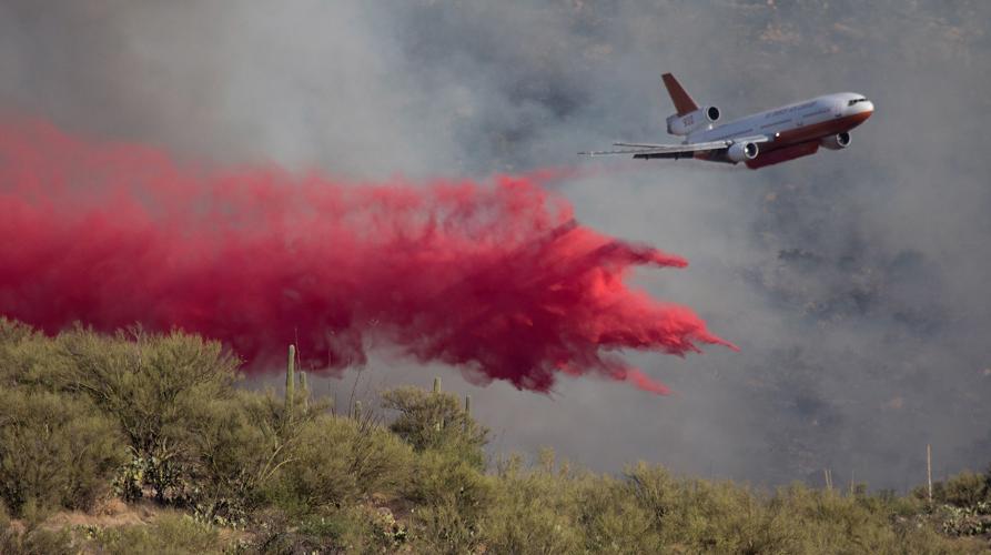
Drone intrusions were a real issue during the fireтs early days, shutting down the firefighting тairshow,т said Steve Miranda, a Forest Service aviation staff officer.
тThat airshow, if it goes away, it makes it more challenging for firefighters on the ground to be successful. They need that water. ... In May, June and July it was the hottest May, June and July on record,т Miranda said in an Aug. 13 webinar sponsored by the UAтs УлшжжБВЅ Institute for Resilience and УлшжжБВЅ Public Media, among other entities.
Incidents like this тquite rightfullyт create a public and press perception that is negative about drones, said Mike Overstreet, a УлшжжБВЅ-area TV producer who uses drones in about 10% of his productions.
тBecause of these idiots who go out and do things dangerously, fly over fires, fly at night and hinder law enforcement, it gives the whole genre of drone operations a very negative tone,т Overstreet said. тWhereas, in fact, drones are a very safe way to view things that cannot be viewed in normal circumstances.т
Drones are dangerous because they can fall on people or structures and hurt them, Overstreet said.
тMore importantly, they are a hazard to low-flying aircraft, and over a fire is where you have, by design, low-flying aircraft,т he said. тYou put a tanker that is flying at 500 feet, and then you have some overzealous drone operator who wants to be at 500 feet. Then the drone becomes dangerous to aircraft. The consequences are unimaginable.
тWe really need to find ways to prosecute more of these people who cause problems. The problem is, of course, finding them,т Overstreet said.
Itтs quite frustrating but understandable that authorities would have trouble tracking down the drone operator, said Matthew Grossman, a licensed, commercial drone pilot and a private airplane pilot. He is active in issues on Mount Lemmon, where the Bighorn Fire raged.
Drone registration numbers are only required to be posted in such a way that they can be read if the drone is retrieved (usually after a crash). Theyтre not like a license plate or tail number on a manned aircraft which can be read with binoculars from a distance, said Grossman. He is the Mount Lemmon Business Economic Associationтs treasurer and a Mount Lemmon Homeowners Association board member.
While тa token prosecutionт can be useful in getting the word out to drone operators about their practiceтs risks, the best outcome of catching someone violating the firefighting airspace would be to file claims against the operatorтs insurance company, he said, to help offset the firefighting costs and losses suffered by businesses evacuated.
A flash flood hit the CaУБada del Oro Wash near Edwin Road in July 2020, during the burning of the massive Bighorn Fire in the Catalina Mountains north of УлшжжБВЅ. The flash flood carried burned debris and runoff from the fire.Т
Photos: The Bighorn Fire burn scar in the Santa Catalina Mountains
Bighorn Fire Burn Scar, hiking trails

Gregg Sasek, dispersed recreation manager for the Coronado National Forest Santa Catalina Ranger District, demonstrates how ground along the Palisade Trail has been burnt out making it easy for hikers to sink a leg into the soil, on Aug. 12, 2020. Various dangers are still being accessed throughout the Coronado National Forest as a result of the Bighorn Fire. Pool photo by Josh Galemore / УлшжжБВЅ
Bighorn Fire Burn Scar, hiking trails

Santa Catalina District Ranger CJ Woodard looks at the burn scar caused by the Bighorn Fire along the Palisade Trail in the Santa Catalina Ranger District of the Coronado National Forest, on Aug. 12, 2020. Pool photo by Josh Galemore / УлшжжБВЅ
Bighorn Fire Burn Scar, hiking trails

A scorched tree along the Palisade Trail in the Santa Catalina Ranger District of the Coronado National Forest, on Aug. 12, 2020. Dangers including burnt vegetation, unstable trees and loose soil as a result of the Bighorn Fire are being accessed by the Forest Service before trails in the area are opened to the public. Pool photo by Josh Galemore / УлшжжБВЅ
Bighorn Fire Burn Scar, hiking trails

A tree uprooted by burnt roots and soil as a result of the Bighorn Fire along the Palisade Trail in the Santa Catalina Ranger District of the Coronado National Forest, on Aug. 12, 2020. Pool photo by Josh Galemore / УлшжжБВЅ
Bighorn Fire Burn Scar, hiking trails

Gregg Sasek, dispersed recreation manager with the Coronado National Forest Santa Catalina Ranger District, leads media and other Forest Service workers along the Palisade Trail to showcase various types of damage done to wilderness area as a result of the Bighorn Fire, on Aug. 12, 2020. Pool photo by Josh Galemore / УлшжжБВЅ
Bighorn Fire Burn Scar, hiking trails

A scorched tree along the Palisade Trail in the Santa Catalina Ranger District of the Coronado National Forest, on Aug. 12, 2020. Dangers including burnt vegetation, unstable trees and loose soil as a result of the Bighorn Fire are being accessed by the Forest Service before trails in the area are opened to the public. Pool photo by Josh Galemore / УлшжжБВЅ
Bighorn Fire Burn Scar, hiking trails

Ponderosa Pines charred by the Bighorn Fire stand along the Palisade Trail in the Santa Catalina Ranger District of the Coronado National Forest, on Aug. 12, 2020. Pool photo by Josh Galemore / УлшжжБВЅ
Bighorn Fire Burn Scar, hiking trails

A tree uprooted and burnt as a result of the Bighorn Fire along the Palisade Trail in the Santa Catalina Ranger District of the Coronado National Forest, on Aug. 12, 2020. Pool photo by Josh Galemore / УлшжжБВЅ
Bighorn Fire Burn Scar, hiking trails

Gregg Sasek, dispersed recreation manager with the Coronado National Forest Santa Catalina Ranger District, carries a combi-tool (a woodland fire tool which combines a shovel and pick) as he leads media and other Forest Service personnel along the Palisade Trail to showcase various types of damage done to wilderness area as a result of the Bighorn Fire, on Aug. 12, 2020. Pool photo by Josh Galemore / УлшжжБВЅ
Bighorn Fire Burn Scar, hiking trails

Forest Service personnel and media walk through a burn scar caused by the Bighorn Fire along the Palisade Trail in the Santa Catalina Ranger District of the Coronado National Forest, on Aug. 12, 2020. Pool photo by Josh Galemore / УлшжжБВЅ
Bighorn Fire Burn Scar, hiking trails

Forest Service personnel and media walk through a burn scar caused by the Bighorn Fire along the Palisade Trail in the Santa Catalina Ranger District of the Coronado National Forest, on Aug. 12, 2020. Pool photo by Josh Galemore / УлшжжБВЅ
Bighorn Fire Burn Scar, hiking trails

Gregg Sasek, dispersed recreation manager with the Coronado National Forest Santa Catalina Ranger District, leads media and other Forest Service workers along the Palisade Trail to showcase various types of damage done to wilderness area as a result of the Bighorn Fire, on Aug. 12, 2020. Pool photo by Josh Galemore / УлшжжБВЅ
Bighorn Fire Burn Scar, hiking trails

A fern sprouts from the soil in a burnt out area along the Palisade Trail in the Santa Catalina Ranger District of the Coronado National Forest, on Aug. 12, 2020. Pool photo by Josh Galemore / УлшжжБВЅ
Bighorn Fire Burn Scar, hiking trails

Gregg Sasek, dispersed recreation manager with the Coronado National Forest Santa Catalina Ranger District, checks tree tops for signs of burn while leading media and other Forest Service workers along the Palisade Trail to showcase various types of damage done to wilderness area as a result of the Bighorn Fire, on Aug. 12, 2020. Pool photo by Josh Galemore / УлшжжБВЅ
Bighorn Fire Burn Scar, hiking trails

A burn scar along the Palisade Trail in the Santa Catalina Ranger District of the Coronado National Forest, on Aug. 12, 2020. Pool photo by Josh Galemore / УлшжжБВЅ
Bighorn Fire Burn Scar, hiking trails

A tree base scorched by the Bighorn Fire along the Palisade Trail in the Santa Catalina Ranger District of the Coronado National Forest, on Aug. 12, 2020. The weakening of the base makes it easier for trees to fall and are a serious danger to hikers. Pool photo by Josh Galemore / УлшжжБВЅ
Bighorn Fire Burn Scar, hiking trails

Gregg Sasek, dispersed recreation manager with the Coronado National Forest Santa Catalina Ranger District, walks by a "leaner" (an uprooted tree hung up on another tree or object) as he leads media and other Forest Service workers along the Palisade Trail to showcase various types of damage done to wilderness area as a result of the Bighorn Fire, on Aug. 12, 2020. Pool photo by Josh Galemore / УлшжжБВЅ
Bighorn Fire Burn Scar, hiking trails

A burn scar from the Bighorn Fire along a hilltop near the Palisade Trail in the Santa Catalina Ranger District of the Coronado National Forest, on Aug. 12, 2020. Pool photo by Josh Galemore / УлшжжБВЅ
Bighorn Fire Burn Scar, hiking trails

Scorched pine needles along the Palisade Trail in the Santa Catalina district of the Coronado National Forest, on Aug. 12, 2020. Pool photo by Josh Galemore / УлшжжБВЅ
Bighorn Fire

Bighorn Fire scar north of Summerhaven, Ariz, right, on July 15, 2020. The Mt. Lemmon Fire station is top center in the photo.
Bighorn Fire

Bighorn Fire in the Santa Catalina Mountains below Summerhaven, Ariz, right, on July 15, 2020.
Bighorn Fire

Bighorn Fire scar in the Santa Catalina Mountains north of Summerhaven (lower right) on July 15, 2020.
Bighorn Fire

Bighorn Fire scar in the Santa Catalina Mountains below the town of Summerhaven on July 15, 2020.
Bighorn Fire

The Mt. Lemmon Control Road cuts through the Bighorn Fire scar on the north side of the Santa Catalina Mountains near Oracle, Ariz., on July 15, 2020.
Bighorn Fire

Bighorn Fire scar below Mt. Lemmon in the Santa Catalina Mountains on July 15, 2020.
Bighorn Fire

Bighorn Fire scar area: CaУБada del Oro basin looking south at Samaniego Ridge in the Santa Catalina Mountains north of УлшжжБВЅ on July 1, 2020. The summit of Mt Lemmon is at left.
Bighorn Fire

The Bighorn Fire scar area shown looking from East Ski Run toward Oracle Ridge, left, and Sanmaniego Ridge, right, in the Santa Catalina Mountains north of УлшжжБВЅ.
Bighorn Fire

Bighorn Fire scar area: South face of Mt Kimball on July 3, 2020, in the Santa Catalina Mountains north of УлшжжБВЅ.
Bighorn Fire

Bighorn Fire scar area: Regional Flood Control Staff installing a new real-time ALERT rainfall monitoring site in the burn area in the Santa Catalina Mountains north of УлшжжБВЅ in July, 2020. These are the backbone of the flash flood warning system.
Bighorn Fire

Charred debris from the Bighorn Fire moves down the CaУБada del Oro Wash after a monsoon storm on July 15, 2020.
Bighorn Fire

Charred debris from the Bighorn Fire moves down the CaУБada del Oro Wash after a monsoon storm on July 15, 2020.
Contact reporter Tony Davis at tdavis@tucson.com or 806-7746. On Twitter@tonydavis987.

Tony Davis
Reporter