

A new state report showing massive over-drafting in five rural groundwater basins doesnãt discuss subsidence, the settling of the ground that occurs when over-pumping hollows out an aquifer and the aquifer collapses.
But all five agriculture-dominant basins studied by the ûÜÒøøÝýË Department of Water Resources already have some level of subsidence. And Brian Conway, ADWRãs subsidence expert, said that if groundwater over-drafting continues or increases in those basins, subsidence will likely continue there ã with ûÜÒøøÝýË Countyãs Willcox Basin likely taking the lead.
More fissuring is definitely a possibility as well with continued over-pumping, he said. Conway is a hydrogeologist and supervisor of ADWRãs geophysical surveying unit.
ãI donãt see it necessarily slowing down or stopping,ã Conway said of the land subsidence problem. But one thing that could stop it is if all the compressible soils in the ground ã mainly clay and silt ã become completely compressed, leaving no more material to subside further.
People are also reading…
The Willcox Basin is by far the stateãs biggest subsidence and fissuring hotspot, ADWR statistics show. The ground in that basin is known to be sinking a half-foot yearly in two places. One is at a spot northwest of Willcox. The other is near the intersection of ûÜÒøøÝýË Stronghold and Dragoon roads in the ûÜÒøøÝýË area.
The spot northwest of Willcox has sunk nearly 11.6 feet since 1969. If it keeps sinking at that rate, the ground could in about 40 years fall a total of 30 feet, Conway said. Thatãs a similar rate to whatãs already occurred in Californiaãs farm-heavy Central Valley.
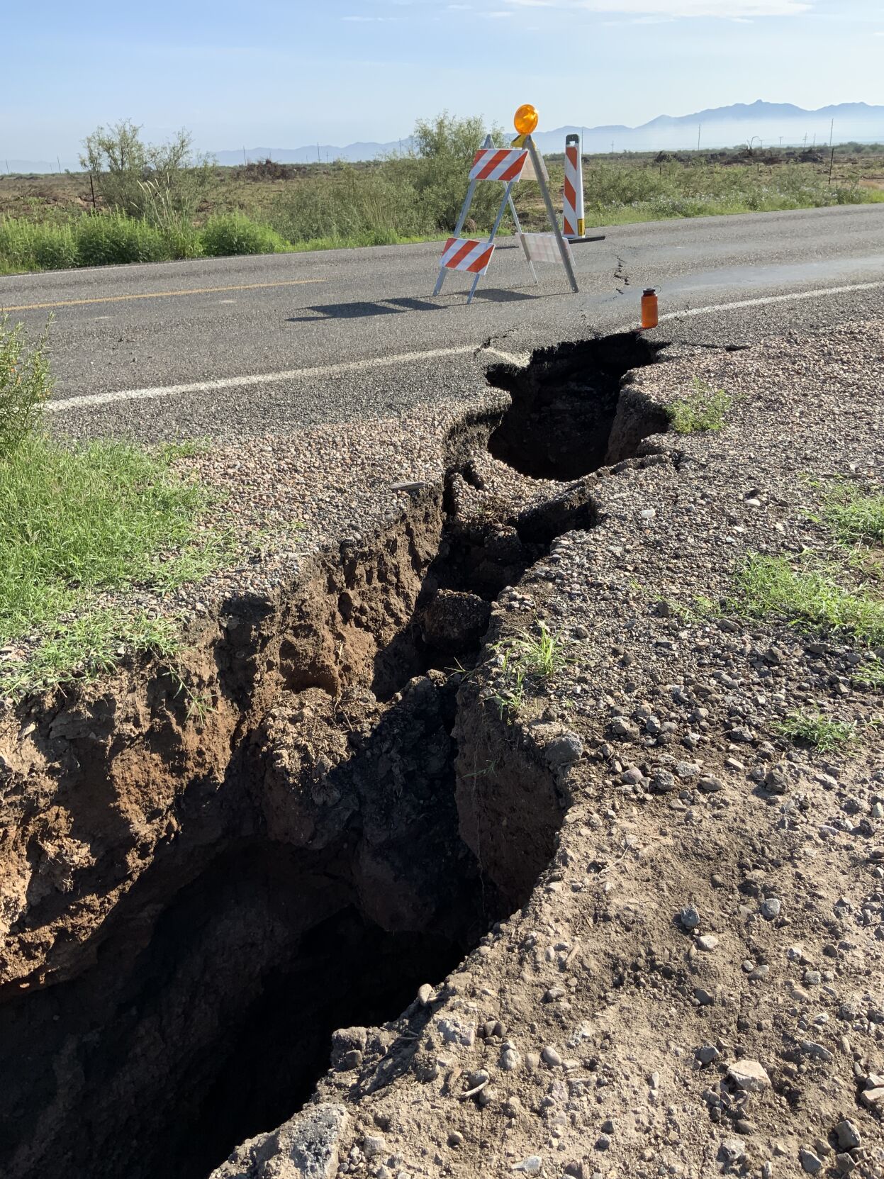
Subsidence and the resulting cracks in the ground caused by fissuring can force road closures and damage wells, water delivery canals and other infrastructure and at times even undercut homes.
The McMullen Valley in western ûÜÒøøÝýË has also sunk 5.6 feet in an area west of the town of Wenden since 1991. The Douglas Basin in ûÜÒøøÝýË County has sunk 5.25 feet in one spot in the town of Elfrida since 1991, Conway said.
The Willcox Basin also leads the state in earth fissuring. The state has mapped about 48 of ûÜÒøøÝýËãs 200 total miles of visible fissures in the Willcox area.
The ûÜÒøøÝýË Geological Survey is aware of about 1.5 more additional miles of fissuring on private property in the Willcox Basin that it hasnãt mapped, said Joe Cook, a research geologist for the survey. They lie on land just west of the Coronado Dairy, near Kansas Settlement Road.
ãWe have mapped new fissures earlier this year all around Willcox,ã Cook said.
ãSome were pretty impressive in person,ã most notably a fissure along Parker Ranch Road in the Kansas Settlement area, he said.
That fissure lies just south of a group of farm fields and two miles south of Coronado Dairy, Cook said. The dairy is owned by Minnesota-based Riverview LLP.
Fissures that cross Parker Ranch Road have been active off and on since about 2010. They have been reactivated and damaged the road several times since then, most recently during 2021ãs summer monsoon season, Cook said.
Get your morning recap of today's local news and read the full stories here: tucne.ws/morning


