

The ├█Ķųų▒▓ź Legislature has budgeted $335 million for border barrier construction. But what will actually be built might be a combination of a virtual wall and barriers around critical infrastructure not directly on the border, the GovernorŌĆÖs Office says.
A ŌĆ£virtual wallŌĆØ could include motion sensors, infrared cameras, mobile towers and aerial drones, which is the type of surveillance technology already being used by the Border Patrol and other law enforcement, said Republican Gov. Doug DuceyŌĆÖs spokesman C.J. Karamargin.
The state could also use the border wall funding to protect ŌĆ£critical infrastructure,ŌĆØ Karamargin said, which could include things like canals, wastewater treatment plants and defense installations, such as the Barry M. Goldwater Air Force Range and Fort Huachuca, which have both had reports of undocumented migrant crossings.
People are also reading…
ŌĆ£All of these things are being analyzed right now, where barriers, both actual and virtual, could be the most effective,ŌĆØ Karamargin said Friday. ŌĆ£ThereŌĆÖs infrastructure and private property that is on or adjacent to that line that is also being looked at as a place where additional barriers, actual and virtual, could be deployed to reduce the flow of illegal traffic into the United States.ŌĆØ
Officials have not provided any details on whether the state can build anywhere on the actual U.S.-Mexico border line, but itŌĆÖs unlikely.
The state budget bill approved late Wednesday by the Republican-led Legislature included the millions for a border barrier as well as another $209 million for a ŌĆ£border security fundŌĆÖŌĆÖ for things like aid to local sheriffs and prosecutors. Of that fund, $15 million is to transport those who entered ├█Ķųų▒▓ź seeking asylum to other states, although the federal government is already paying for that.
StateŌĆÖs jurisdiction unclear
During the Trump administration there were 226 miles of wall construction planned for the ├█Ķųų▒▓ź-Mexico border, most of which were built. Less than 20 miles were incomplete when President Joe Biden took office and stopped construction, such as in Guadalupe Canyon, about 30 miles east of Douglas, where construction crews blasted into mountainsides but didnŌĆÖt complete construction.
No government agency or state official that the ├█Ķųų▒▓ź contacted provided details on where the state would have jurisdiction to build a border barrier, including the GovernorŌĆÖs Office, nine state lawmakers, the Army Corps of Engineers, Customs and Border Protection, the state Land Department or the Bureau of Land Management.
Data provided by the Army Corps show the ├█Ķųų▒▓ź projects that went unfinished are generally near Sasabe and Nogales in Pima County, Naco in ├█Ķųų▒▓ź County, and areas in Yuma County.
But regardless of where state officials would like to build a border wall, it appears there is practically nowhere on the actual border where the state can build because of a 60-foot-wide federal easement that runs contiguous and adjacent to the entire ├█Ķųų▒▓ź-Mexico border, except over the Colorado River.
The state could build on land it owns that is north of the 60-foot easement, although a majority of public land adjacent to the easement is federally owned.
And the state could build 60 feet north of the border on private land with permission, but privately owned parcels by acreage along the border account for just 3.7%, according to Regrid, a provider of nationwide land parcel data, and some of these properties already have a border wall.
President Theodore Roosevelt created the federal easement, called the Roosevelt Reservation, in 1907 in order to keep all public lands along the border in California, ├█Ķųų▒▓ź and New Mexico ŌĆ£free from obstruction.ŌĆØ Texas was excluded because the state retained all public lands upon its annexation and admittance as a state, much of which has been sold over the years to private parties.
In talks with property owners
├█Ķųų▒▓ź is in talks with private property owners about building some type of barrier on their land, Karamargin said.
ŌĆ£WeŌĆÖre going to put up barriers based on the input from local officials and private property owners where we think they would have the most impact. That could include virtual barriers,ŌĆØ he said.
If ├█Ķųų▒▓ź did want to build a physical wall 60 feet from the border, that would leave gaps where it could not connect with the existing border barrier.
It also would come up against environmental regulations. The federal government was able to accomplish as much wall construction as it did by waiving all such regulation through the Real ID Act, which allowed it to waive laws that interfered with construction of physical barriers at the border. This law does not apply to states.
The state would also likely be responsible for maintenance of the wall, which could be a costly ongoing expense for taxpayers.
Gaps in federal wall
The largest swath of land without wall on the ├█Ķųų▒▓ź border is the 62 miles on the Tohono OŌĆÖodham Nation where neither the federal nor state governments have permission to build a wall, as tribal officials have been vocal in their opposition.
Despite the wall covering much of the Southern ├█Ķųų▒▓ź border, there are many gaps where migrants often pass into the country. One such place thatŌĆÖs received a lot of attention is a gap in Yuma. Border Patrol apprehensions in Yuma increased dramatically over the last 18 months, from 990 apprehensions in November 2020 to more than 33,000 this May.
This gap is also on federal land on the U.S. side and so not somewhere the state could build a wall.
In May, the U.S. Department of Homeland Security announced it would be closing a ŌĆ£small gapŌĆØ in the Border PatrolŌĆÖs Yuma Sector, without specifying exactly where. The federal government also announced in December it would be closing gaps in the wall as part of remediation work that was originally scheduled for this summer but was later pushed to the fall.
No specifics on physical barrier plans
The Star emailed or called nine lawmakers in the ├█Ķųų▒▓ź House and Senate who either hold leadership positions or have been vocal on the state building its own wall. One responded.
Rep. John Kavanagh, R-Fountain Hills, said they arrived at the $335 million figure from information they got from the state Land Department and the GovernorŌĆÖs Office, ŌĆ£in terms of balancing what areas need and what is a reasonable amount that can be constructed within a year based on the availability of materials and construction personnel.ŌĆØ
He said he didnŌĆÖt know how many miles of wall the state could build or where those miles are.
ŌĆ£It really varies by terrain,ŌĆØ he said. ŌĆ£It also is determined by whether we can get existing materials that the federal governmentŌĆÖs not using so itŌĆÖs really impossible to do any kind of reasonable judgment that wouldnŌĆÖt potentially be way off.ŌĆØ
Legislators who didnŌĆÖt respond last week to the StarŌĆÖs questions of how they came up with the $335 million amount and where the state could build a wall include: Sen. Tyler Pace, Sen. Wendy Roger, Senate Majority Leader Ben Toma Jr., Senate Minority Leader Rebecca Rios, Senate President Karen Fann, House Speaker Rusty Bowers, House Majority Leader Rick Gray and House Minority Leader Reginald Bolding. It was a busy final week of the legislative session for lawmakers.
Bolding did put out a statement the day before the budget passed saying, among other things, that the budget ŌĆ£spends more new money on a border fence than on our universities or our affordable housing crisis.ŌĆØ The budget that eventually passed did contain at least $77 million more for universities.
Like Kavanagh, the GovernorŌĆÖs Office talked about a need to fill gaps in the wall and specifically the larger gap in Yuma County.
Karamargin said state officials are assessing now where increased barriers would be appropriate, and that they will be done with that soon.
When asked how the state arrived at the $335 million allocated to build some kind of border barrier and what information they gave legislators, he said they based their assessment on talking with local stakeholders in Yuma and ├█Ķųų▒▓ź counties on where fencing could be appropriate and would have the most impact.
ŌĆ£I can tell you that the needs that weŌĆÖve outlined are based on our regular contact with local and federal partners about the best way resources could be used to increase security,ŌĆØ Karamargin said.
When asked if the state would be able to build on any federal land, he said that is among the questions that need to be answered.
ŌĆ£I think thereŌĆÖs a great sense of urgency on the part of some border communities and businesses to move quickly, so that is our goal,ŌĆØ he said.
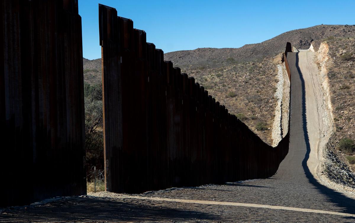
Photos of the U.S. ŌĆō Mexico border fence
U.S. ŌĆō Mexico border near Douglas, Ariz.

A dog stands on a road commonly used by Border Patrol near Slaughter Ranch Museum Thursday, Sept. 27, 2019.
U.S. ŌĆō Mexico border near Douglas, Ariz.
A border monument on the Mexico side of the border seen east of Douglas Thursday, Sept. 27, 2019.
U.S. ŌĆō Mexico border near Douglas, Ariz.

The San Bernardino National Wildlife Refuge sits on the U.S. side of the border with Mexico east of Douglas Thursday, Sept. 27, 2019.
U.S. ŌĆō Mexico border near Douglas, Ariz.

A bull and cow graze near the site of new wall construction east of Douglas Thursday, Sept. 27, 2019.
U.S. ŌĆō Mexico border near Douglas, Ariz.

The border seen stretching from hills east of Douglas into the Guadalupe Mountains Thursday, Sept. 27, 2019.
U.S. ŌĆō Mexico border near Douglas, Ariz.

Flowers grow around border fencing near the San Bernardino National Wildlife Refuge Thursday, Sept. 27, 2019.
U.S. ŌĆō Mexico border near Douglas, Ariz.

Construction equipment set up at the site of new border wall construction on the US/Mexico border east of Douglas Thursday, Sept. 27, 2019.
U.S. ŌĆō Mexico border near Douglas, Ariz.

A Border Patrol tower on the hills east of Douglas Thursday, Sept. 27, 2019.
U.S. ŌĆō Mexico border near Douglas, Ariz.

Memorials place on graves at Julia Page Memorial Park in Douglas which sits along the U.S./Mexico border Thursday, Sept. 27, 2019.
U.S. ŌĆō Mexico border near Douglas, Ariz.

A car drives through Douglas on a road parallel to the U.S./Mexico border wall Thursday, Sept. 27, 2019.
U.S. ŌĆō Mexico border near Douglas, Ariz.

The Slaughter Ranch homestead Thursday, Sept. 27, 2019.
U.S. ŌĆō Mexico border near Douglas, Ariz.

A lake on the Slaughter Ranch Thursday, Sept. 27, 2019.
U.S. ŌĆō Mexico border near Douglas, Ariz.

A toy rocking horse placed on the side of East Geronimo Trail with a sign advertising five minute pony rides for 25 cents Thursday, Sept. 27, 2019.
U.S. ŌĆō Mexico border near Douglas, Ariz.

Highway 2 in Mexico winds its way to Agua Prieta Thursday, Sept. 27, 2019.
U.S. ŌĆō Mexico border near Douglas, Ariz.

The vehicle in a ditch was driven through the international border fence in Agua Prieta, Mex., into Douglas, ├█Ķųų▒▓ź in July 1987.
U.S. ŌĆō Mexico border near Douglas, Ariz.

Mexican citizens run back into Agua Prieta, Mexico through a hole in the border fence at Douglas, Ariz., after the U.S. Border Patrol scared them back across the border in 1997.
U.S. ŌĆō Mexico border near Douglas, Ariz.

The Raul Hector Castro Port of Entry on May 1, 2018, in Douglas, Ariz.
U.S. ŌĆō Mexico border near Douglas, Ariz.

The Douglas, Ariz., border crossing in 1968.
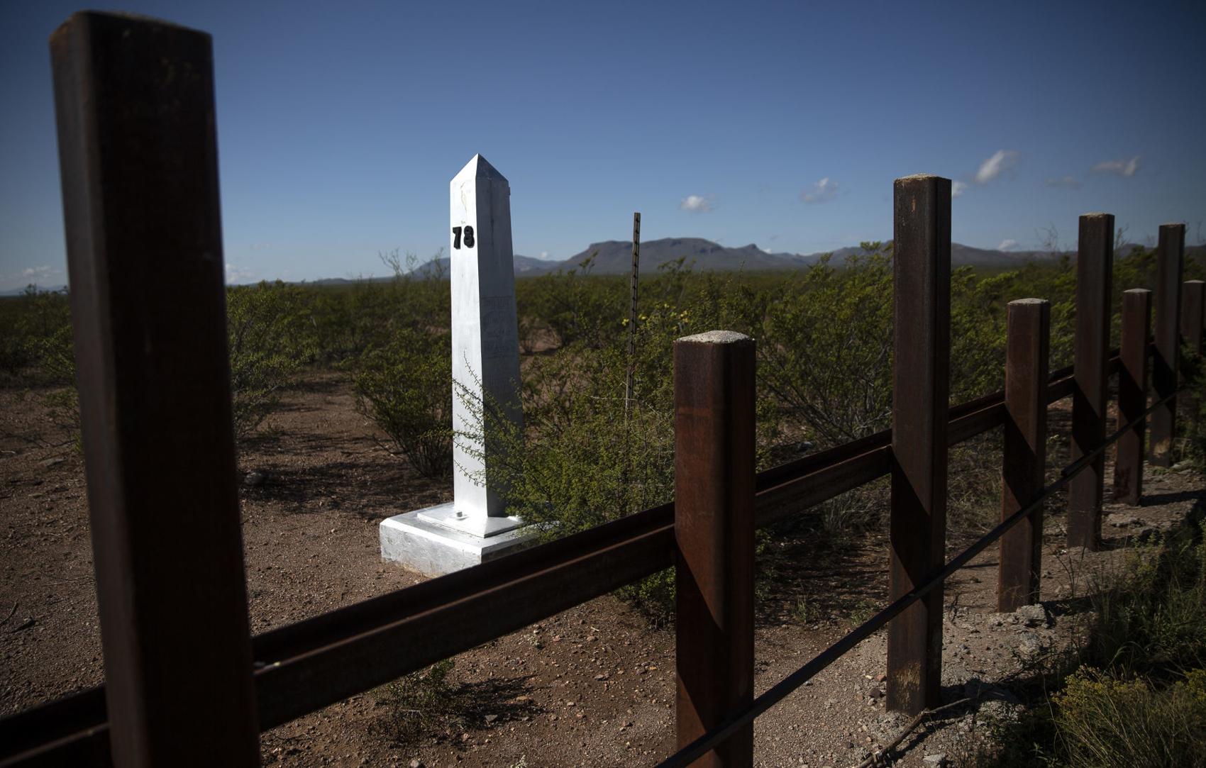
U.S. ŌĆō Mexico border near Lochiel, Ariz.

U.S./Mexico border fencing next to a old church building in Lochiel Tuesday, Oct. 1, 2019.
U.S. ŌĆō Mexico border near Lochiel, Ariz.

Old border posts line the U.S./Mexico line near Lochiel Tuesday, Oct. 1, 2019.
U.S. ŌĆō Mexico border near Lochiel, Ariz.

A Soal Off Roading sticker placed on a U.S./Mexico border post near Lochiel Tuesday, Oct. 1, 2019.
U.S. ŌĆō Mexico border near Lochiel, Ariz.

Mountains in Santa Cruz County seen from Duquesne Road between Nogales and Lochiel seen Tuesday, Oct. 1, 2019.
U.S. ŌĆō Mexico border near Lochiel, Ariz.
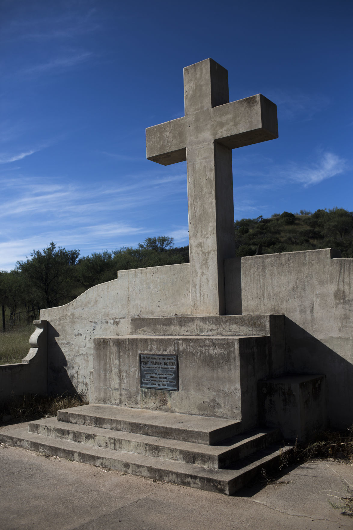
A monument in Lochiel marking where Fray Marcos De Niza entered ├█Ķųų▒▓ź Tuesday, Oct. 1, 2019.Tuesday, Oct. 1, 2019.
U.S. ŌĆō Mexico border near Lochiel, Ariz.

Brothers Ramon and Ed De La Ossa mend fencing on their family's ranch in Lochiel after moving cattle Tuesday, Oct. 1, 2019. The ranch which used to span both sides of the U.S./Mexico border has been in the family for three generations.
U.S. ŌĆō Mexico border near Lochiel, Ariz.

Ed De La Ossa mends fencing on his family's ranch in Lochiel Tuesday, Oct. 1, 2019. The ranch which used to span both sides of the U.S./Mexico border has been in the family for three generations.
U.S. ŌĆō Mexico border near Lochiel, Ariz.

Ed De La Ossa moves cattle on his family's ranch in Lochiel Tuesday, Oct. 1, 2019.
U.S. ŌĆō Mexico border near Lochiel, Ariz.

U.S. Customs inspector Helen Mills, right, greets Mexican counterpart Raymundo Aguirre Castillo at the U.S. - Mexican border station at Lochiel, Ariz., in 1979.
U.S. ŌĆō Mexico border near Lochiel, Ariz.

The US Customs building, right, at Lochiel, Ariz., is just a short distance away from the international border in May 1972. For ten years, Mills has been managing the port of entry, which is mostly made up of five houses, a school and an vacant church, inspecting vehicles as they head into the US. During the week, from Monday through Saturday, Mills opens the border gate from 8 am to 10 am and from 4 pm to 6 pm. On Sunday the gate is open from 8 am to 6 pm. In that time barely a dozen vehicles make their way across the border but it is a major convenience to the local residents.┬Ā
U.S. ŌĆō Mexico border near Nogales, Ariz.

Pedestrians walk to the Nogales port of entry Tuesday, Oct. 1, 2019.
U.S. ŌĆō Mexico border near Nogales, Ariz.

A pedestrian walks across North Grand Avenue in Nogales near the U.S./Mexico port of entries Tuesday, Oct. 1, 2019.
U.S. ŌĆō Mexico border near Nogales, Ariz.

U.S. Customs and Border Protection officer R. Hernandez uses a density-measuring device on the rear quarter-panel of a Mexico-bound passenger vehicle at the DeConcini Port of Entry on Nov. 2, 2016, in Nogales, Ariz.
U.S. ŌĆō Mexico border near Nogales, Ariz.

A Customs and Border Protection officer makes a visual check of a man's identification at the DeConcini Port of Entry on Feb. 15, 2017, in Nogales, Ariz. Busts of fraudulent border-crossing documents and the use of someone else's documents plummeted in ├█Ķųų▒▓ź and the rest of the border in the past decade.
U.S. ŌĆō Mexico border near Nogales, Ariz.

Northbound commercial truck traffic lined up for inspection at the Mariposa Port of Entry on March 28, 2017, in Nogales, Ariz.
U.S. ŌĆō Mexico border near Nogales, Ariz.

In the commercial lanes a semi truck stops between the lanes looking for the first available opening at the Mariposa Port of Entry in 2015.
U.S. ŌĆō Mexico border near Nogales, Ariz.

Javier Castillo inspects a north-bound Mexican tractor-trailer at the ├█Ķųų▒▓ź Department of Transportation's inspection facility at the Mariposa Port of Entry on Sept. 19, 2017, in Nogales, Ariz. ADOT's International Border Inspection Qualification program, led by ADOT's Border Liaison Unit, teaches commercial truck drivers what to expect during safety inspections when they enter ├█Ķųų▒▓ź ports of entry.
U.S. ŌĆō Mexico border near Nogales, Ariz.

A Border Patrol truck parked near the commercial port of entry in Nogales.
U.S. ŌĆō Mexico border near Nogales, Ariz.

An illegal alien scales the U.S.-Mexico fence back toward Sonora after a Nogales Police Department officer, right, spotted him west of the Mariposa Port of Entry, Nov. 15, 2018, in Nogales, Ariz.
U.S. ŌĆō Mexico border near Nogales, Ariz.

Kory's, a store catering to wedding, quinceaŌĆōera and formal gowns, located at 15 N Morley Ave, Nogales, Ariz., sits katty corner to the Morley Gate Border Station on January 30, 2019.
U.S. ŌĆō Mexico border near Nogales, Ariz.

Sun shines through the U.S.-Mexico bollard fence west of the Mariposa Port of Entry, Nov. 15, 2018, in Nogales, Ariz.
U.S. ŌĆō Mexico border near Nogales, Ariz.

Children from Nogales, Sonora, climb through a hole in the international border fence to trick-or-treat in Nogales, ├█Ķųų▒▓ź, on Halloween in 1987.
U.S. ŌĆō Mexico border near Sasabe and Lukeville, Ariz.

Border monument #166 is seen on the right as construction continues on the new 30-foot tall bollard fence that replaces old U.S./Mexico border fence two miles east of the Lukeville, ├█Ķųų▒▓ź port of entry on October 8, 2019. Photo taken from Sonoyta, Sonora, Mexico.
U.S. ŌĆō Mexico border near Sasabe and Lukeville, Ariz.

Construction continues on the new 30-foot tall bollard fence along the U.S./Mexico border two miles east of the Lukeville, ├█Ķųų▒▓ź port of entry on October 8, 2019. Photo taken from Sonoyta, Sonora, Mexico.
U.S. ŌĆō Mexico border near Sasabe and Lukeville, Ariz.

A Mexican worker rides his horse along a road south of the U.S./Mexican border wall on his way back into Sonoyta Wednesday, Aug. 28, 2019.
U.S. ŌĆō Mexico border near Sasabe and Lukeville, Ariz.

New paneling of border wall seen about three miles east of the Lukeville/Sonoyta port of entry seen from the Mexico side of the border line Wednesday, Aug. 28, 2019.
U.S. ŌĆō Mexico border near Sasabe and Lukeville, Ariz.

Old mesh paneling is removed in preparation for new wall to be built about three miles east of the Lukeville/Sonoyta port of entry seen from the Mexico side of the border line Wednesday, Aug. 28, 2019.
U.S. ŌĆō Mexico border near Sasabe and Lukeville, Ariz.

A construction worker prepares cables to lift a piece of the 30-foot tall bollard fence along the U.S./Mexico border fence two miles east of the Lukeville, ├█Ķųų▒▓ź port of entry on October 8, 2019. Photo taken from Sonoyta, Sonora, Mexico.
U.S. ŌĆō Mexico border near Sasabe and Lukeville, Ariz.

Border Patrol Officers to the side of a worksite about three miles east of the Lukeville/Sonoyta port of entry where new border wall is being installed seen from the Mexico side of the border line Wednesday, Aug. 28, 2019.
U.S. ŌĆō Mexico border near Sasabe and Lukeville, Ariz.

Old wall east of the Lukeville/Sonoyta port of entry seen from the Mexico side of the border line Wednesday, Aug. 28, 2019.
U.S. ŌĆō Mexico border near Sasabe and Lukeville, Ariz.

Raised wall east of the Lukeville/Sonoyta port of entry seen from the Mexico side of the border line Wednesday, Aug. 28, 2019.
U.S. ŌĆō Mexico border near Sasabe and Lukeville, Ariz.

A work site east of the Lukeville/Sonoyta port of entry seen from the Mexico side of the border line Wednesday, Aug. 28, 2019.
U.S. ŌĆō Mexico border near Sasabe and Lukeville, Ariz.

Normandy fencing placed against a section of border fence west of Lukeville Wednesday, Aug. 28, 2019.
U.S. ŌĆō Mexico border near Sasabe and Lukeville, Ariz.

A semi passes by Quitobaquito Springs as it drives along Highway 2 in Mexico Wednesday, Aug. 28, 2019.
U.S. ŌĆō Mexico border near Sasabe and Lukeville, Ariz.

An area referred to as "flood gate" along the U.S./Mexico border near Sasabe, Ariz. is on the list of the Department of Homeland SecurityŌĆÖs priorities for building a border wall, but no funding has been allocated yet. September 16, 2019.
U.S. ŌĆō Mexico border near Sasabe and Lukeville, Ariz.

Vehicle barriers mark the U.S./Mexico border within the Buenos Aires National Wildlife Refuge in Sasabe, Ariz. on September 16, 2019.
U.S. ŌĆō Mexico border near Sasabe and Lukeville, Ariz.

A portion of the U.S./Mexico bollard border fence ends on the right and vehicle barriers begin within the Buenos Aires National Wildlife Refuge in Sasabe, Ariz. on September 16, 2019.
U.S. ŌĆō Mexico border near Sasabe and Lukeville, Ariz.

A U.S. Customs and Border Protection Integrated Fixed Tower, left, near Sasabe, Ariz. on September 16, 2019.
U.S. ŌĆō Mexico border near Sasabe and Lukeville, Ariz.

The new 30-foot tall bollard fence that replaced old U.S./Mexico border fence can be seen on the left. It's located about miles east of the Lukeville, ├█Ķųų▒▓ź port of entry on October 8, 2019. Photo taken from Sonoyta, Sonora, Mexico.
U.S. ŌĆō Mexico border near San Luis, Ariz.

A US Border Patrol vehicle seen next to a section of new 30 foot high wall along the US/Mexico border near the commercial port of entry in San Luis Thursday, Aug. 8, 2019.
U.S. ŌĆō Mexico border near San Luis, Ariz.

Old fencing is taken down along the United States/Mexico border seen from the northern end of San Luis, Mexico, Aug. 7, 2019.
U.S. ŌĆō Mexico border near San Luis, Ariz.

A security guard stand in a construction site where a new fence will be placed on the United States/Mexico border seen from the northern end of San Luis, Mexico, Aug. 7, 2019.
U.S. ŌĆō Mexico border near San Luis, Ariz.

Old fencing against new fencing along the United States/Mexico border seen from the northern end of San Luis, Mexico on Aug. 7, 2019.
U.S. ŌĆō Mexico border near San Luis, Ariz.

Crews prepare ground for a new fence to be placed on the United States/Mexico border seen from the northern end of San Luis, Mexico on Aug. 7, 2019.
U.S. ŌĆō Mexico border near San Luis, Ariz.

Vehicles in line to enter the United States from San Luis, Mexico on Aug. 7, 2019.
U.S. ŌĆō Mexico border near San Luis, Ariz.

New fencing along the United States/Mexico border seen from the northern end of San Luis, Mexico on Aug. 7, 2019.
U.S. ŌĆō Mexico border near San Luis, Ariz.

A new section of fencing on the U.S. - Mexico border in California, just west of Yuma, Ariz., in 1993.
U.S. ŌĆō Mexico border near San Luis, Ariz.

Sand drifts through the "floating fence" that marks the border running through the dunes, Wednesday, July 25, 2018, west of San Luis, Ariz.
U.S. ŌĆō Mexico border near San Luis, Ariz.

A sign warns of the dangers of trying to swim the All-American Canal just north of the Mexican border, Wednesday, July 25, 2018, west of San Luis, Ariz.
U.S. ŌĆō Mexico border near San Luis, Ariz.

A long string of lights illuminate the no-man's land between the triple fencing of the Mexican border, Wednesday, July 25, 2018, San Luis, Ariz.
U.S. ŌĆō Mexico border near San Luis, Ariz.

The border fence comes to an abrupt end at the currently dry Colorado River, Thursday, July 26, 2018, west of San Luis Rio Colorado, Sonora.
Contact reporter Danyelle Khmara at dkhmara@tucson.com or 573-4223. On Twitter:

Danyelle Khmara
Reporter


