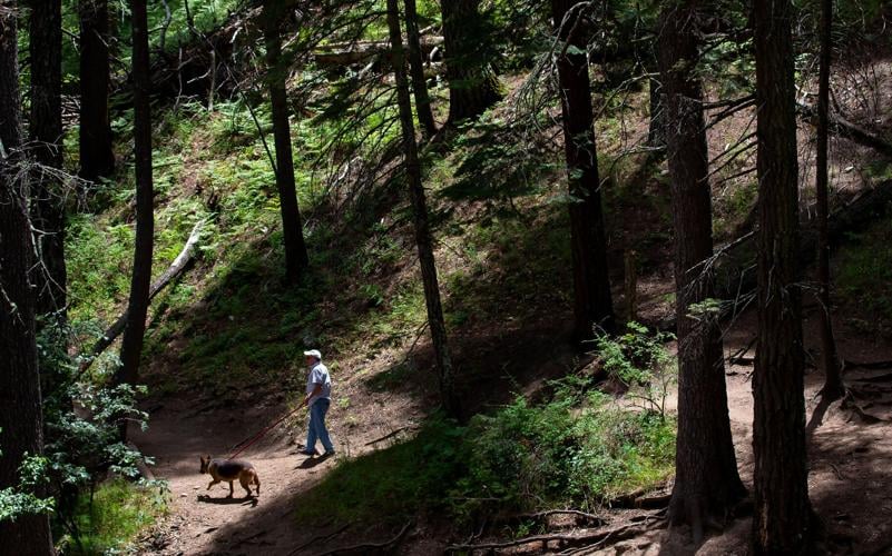
An aspirational trail plan envisions more trails and better facilities for mountain bikers, equestrians and people with limited mobility in ├█Ķųų▒▓źŌĆÖs Santa Catalina mountains.
The draft Santa Catalina trail plan suggests more trails for the 250-mile trail system on the Forest ServiceŌĆÖs Santa Catalina Ranger District but also some lesser-used, fire-damaged trails removed from its system (and thus from maintenance). The district encompasses the Santa Catalina and Rincon mountains northeast of ├█Ķųų▒▓ź enfolding Saguaro National Park (removed from national forest in 1933).
ŌĆ£ThatŌĆÖs the tension of the plan,ŌĆØ said Adam Milnor, recreation staff officer on the Coronado National Forest and leader of the forest-district planning team. ŌĆ£Many people want so much from these trails. We heard lots of requests for more trails.ŌĆØ No one likes to see trails removed from the map, but the overall aim is to ŌĆ£meet several needs and give us the biggest bang for the buck.ŌĆØ
People are also reading…
The draft plan proposes adjusting the trail system over 15 years for a 10% net gain ŌĆö up to 275 miles of trail. This includes:
Building almost 24 miles of new trail.
Adopting almost 23 miles of existing but ŌĆ£unauthorizedŌĆØ trails created by people, livestock or wildlife.
Rerouting 18 miles of trail.
Closing about 21 miles of trail.
Environmental analyses would be required for any new trail construction, and non-system trails proposed for adoption offer legal, access and mixed ownership challenges.
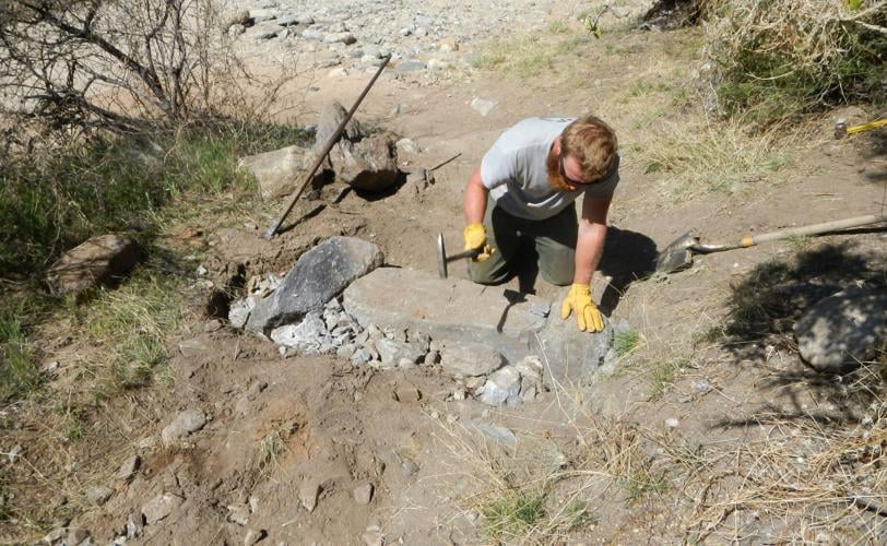
Max Miller, a mason from Michigan, moves, sets and taps in rocks for check dams in Saguaro National Park.
This is the first overall plan for the sprawling trail system which evolved from trails used by Native Americans and wildlife and later improved by Civilian Conservation Corps and the Forest Service. It responds to evolving trail use patterns, and addresses parking needs, user conflicts and trail degradation worsened by the Bighorn Fire of 2020, while protecting wildlife and other resources.
The current system ŌĆ£has a lopsided range of trail difficulty, offering an abundance of higher difficulty trails with steep grades and rough tread servicesŌĆØ with few trails for beginners, the plan states. Only 20% is usable by mountain bikes; 47% of the district is within the Pusch Ridge Wilderness and closed to mechanized use.
The plan, online at , offers details on trail issues, status, use and proposals. The final plan could be released next March with priority projects underway by next fall ŌĆö depending on what people want.
ŌĆ£We are relying on our partners and the public for help with priorities,ŌĆØ Milnor said. ŌĆ£Do people want visible results, early wins or longer-term projects?ŌĆØ He hopes to see specific comments on what people like, donŌĆÖt like and want done.
Send written comments via email to sm.fs.scrd@usda.gov by Dec. 2. Non-internet users can request a printed copy of the draft plan by calling 520-388-8300 and can submit written comments to Adam Milnor c/o Forest Supervisor’s Office, Coronado National Forest, 300 W. Congress St., ├█Ķųų▒▓ź, AZ 85701.
A map set at shows all proposed trail and other facility projects.
New trails for all
The 8.5-mile ├█Ķųų▒▓ź Vista Trail, envisioned as a gentle multi-use trail with signs in English and Spanish, would link Rose Canyon with several trailheads along Santa Catalina Highway.
It might also be the new bike route for ├█Ķųų▒▓ź National Scenic Trail (commonly known as AZT). The current ŌĆ£bypass routeŌĆØ (for cyclists not allowed where the trail crosses Pusch Ridge Wilderness) follows steep road and trail sections, some not bike-friendly and unsafe for horses. Brannon Mamula, ├█Ķųų▒▓ź Off-Road Cyclists and Activists (TORCA) president, calls a set of eroded high wooden bars (dams to divert water) on Bug Spring Trail: ŌĆ£Bike-A-Hike.ŌĆØ
Evan Piling, a trail builder with American Conservation Experience, said Vista Trail would be logistically reasonable to build as it uses existing roadbeds and moderate terrain ŌĆö rare in the steep rocky Catalinas. Piling did feasibility scouting for proposed trails.

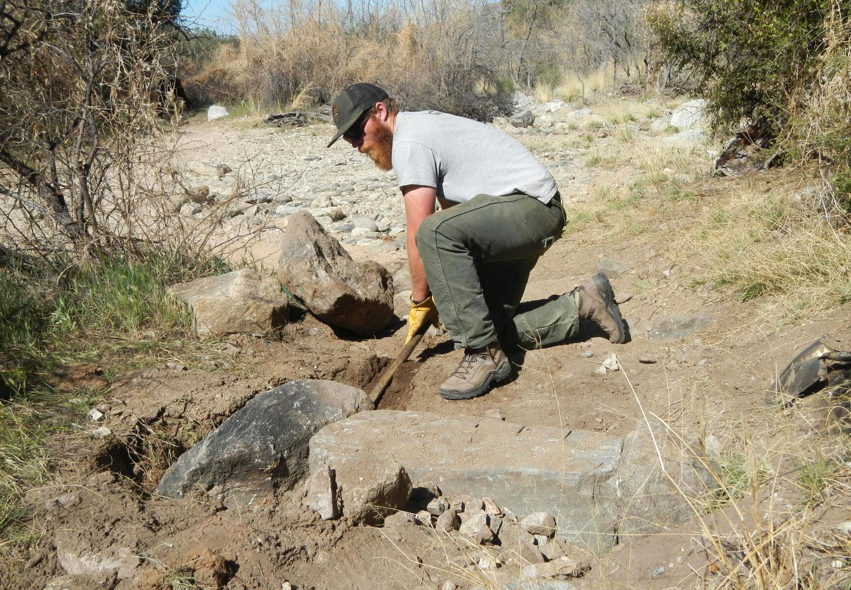
Max Miller, a mason from Michigan, works on a trail in Saguaro National Park, part of the Santa Catalina Ranger District, which is the focus of a proposed trail plan.
New mileage for bikers
In addition to the multi-use trail, the growing population of mountain bikers may gain new mileage if the Forest Service builds some bike-specific trails and ŌĆ£adoptsŌĆØ other existing ones.
The proposed ŌĆ£Bug JuniorŌĆØ Trail would parallel Bug Spring Trail as a downhill only mountain bike route ŌĆö the first ŌĆ£directional mountain bike trailŌĆØ on the Coronado. A proposed ŌĆ£fuel breakŌĆØ (strip of land where vegetation is reduced for fire control) on Mt. Bigelow could be a downhill mountain bike trail. TORCAŌĆÖs Mamula also cited proposed connector trails for more loop trips.
The plan proposes adopting 21 miles of ŌĆ£unauthorizedŌĆØ trails, existing trails created by users. It estimates 240 miles of such routes with 40 miles regularly used. Key prospects are Milagrosa Trail near Reddington Pass and the ŌĆ£Golder RanchŌĆØ system, 17 miles of multi-use trails on national forest along Golder Ranch Road in the western Catalina Foothills.
Milagrosa, which connects private and Pima County land to Bellota/AZT east of Molino Basin, would require work with Pima County for permanent legal access for the trail.
ŌĆ£Golder RanchŌĆØ area between Golder Ranch Road and Catalina State Park hosts a network of routes around the 50-Year Trail between the park and forest. This 7.3-mile trail is on state trust lands protected by a 50-year lease agreement between ├█Ķųų▒▓ź State Parks and Trails and the ├█Ķųų▒▓ź State Land Department. Land could be sold for development when the lease expires in 2038. Adoption would require purchasing lands or an easement for permanent public access.
ŌĆ£WeŌĆÖre thrilled,ŌĆØ said Bev Showalter from the equestrian County Line Riders of Catalina and Pima Trails Association, who has worked decades for legal public access to Golder Ranch trails.
Expanded hiking options
The proposed Mt. Lemmon Interpretive Trail would be a paved route for first-time visitors and those with limited mobility, featuring bilingual interpretive signs on the Indigenous and historical context of the Santa Catalinas, designed with help of Native tribes who first used the area.
Proposed connectors include a trail in Molino Canyon; access trail from Rose Canyon; a trail between Marshall Gulch and Summerhaven, and a trail linking routes to upper and lower Tanque Verde Falls east of Reddington Pass Road. This trail is already being built.
Front range trails such as Pima Canyon, Finger Rock, Ventana, Esperero and the remote crest trail between Pima and West Fork Sabino canyons would see small reroutes and new connectors including a 1.7-mile trail linking Finger Rock and Pontatoc trails for a day-hiking loop trip.
New trail hubs and vehicle/horse trailer parking could result from repurposing the old Palisades Ranger Station as a visitor center and reconfiguring Gordon Hirabayashi recreation site.
Trail reroutes: The ├█Ķųų▒▓ź Trail
The ├█Ķųų▒▓ź National Scenic Trail (AZT) from Mexico to Utah runs 53 miles and another 22 miles of bypass route in the Catalinas. The long-term goal is to remove the trail from roads where possible. The draft plan envisions rerouting 8 miles of AZT from Oracle Ridge. Matthew Nelson, executive director of ├█Ķųų▒▓ź National Scenic Trail Association, said this route is eroded and no longer safe; further it parallels a dirt road now used by heavy equipment for mineral development on adjacent private property.
User conflicts and safety issues
In Aspen Draw, a trail near Summerhaven with mountain bike-hiker use conflict, the Forest Service would try a yearlong test trail user allocation system where the trail would be open either to bikers or hikers on odd or even weekend days and open to all users on weekdays.
Better access and safety for rock climbers could occur from maintaining trails to rock climbing areas. First proposed is Crags Against Humanity, a low elevation climb near Catalina Highway.
Proposed trail ŌĆśremovalsŌĆÖ
Several trails could be ŌĆ£removedŌĆØ from the Catalina system ŌĆö they would no longer be maintained and not shown on new maps. This could include lower Brush Corral and Evans Mountain near Reddington Pass, and the brushy lower end of Box Camp Trail. These trails are remote with less use or are redundant with other trails, Milnor said. For example, Palisades Trails parallels Box Camp connecting the highway to East Fork Sabino Trail (AZT route).
On the westside, Sutherland and Canada del Oro (CDO) trails ŌĆö badly damaged by Bighorn Fire ŌĆö might be removed. Forest officials want to rebuild Samaniego Trail. It parallels CDO to Mt. Lemmon and could link to , an ambitious multi-use trail project linking Las Vegas, Kingman, Flagstaff, Prescott, Phoenix and ├█Ķųų▒▓ź.
Romero Canyon Trail, which links Catalina State Park to Mt. Lemmon trails and the AZT, is being rebuilt after major damage from Bighorn Fire. Milnor said the $40,000 cost has come from emergency post-fire funds and National Forest Foundation grants.
Trail funding boost
The Coronado plan for boosting the trail system is timely ŌĆö funds from recent legislation more than tripled the forestŌĆÖs trail maintenance funds over the past two years and offers hope of continued trail funding (subject to yearly Congressional approval) through 2027.
The of 2020 directs revenues from energy development for up to $1.9 billion a year maintenance for infrastructure on national parks, forests, wildlife refuges, recreation areas and Bureau of Indian Education schools over five years.
CoronadoŌĆÖs yearly trail budget is only $50,000 forest-wide but the Great American Outdoors Act funding added $325,000 over past two years, Milnor said. Trail maintenance costs $5,000 to $8,000 per mile. New trail construction costs $25,000 to $75,000 per mile, but projects like the Vista Trail may cost less by re-using old roads and utilizing planning/construction work help from partner groups.
Trail users also benefit indirectly from two big Outdoors Act projects ŌĆö $2.2 million to repave Sabino Canyon and $2.4 million to enlarge and improve parking for Marshall Gulch.
ŌĆ£We have more daily use in Sabino than on the rest of the mountain,ŌĆØ Milnor said.
Increased usage
An ├█Ķųų▒▓ź State survey last year found that 63% of Pima County residents reported using the Santa Catalina trail system at least once in the year, Milnor said. Tourism data also showed that some people visit trails from up to 500 miles away.
Milnor said there is also a shift from backcountry to front range use for hikers and trail joggers.
ŌĆ£Daily trail use has become part of peopleŌĆÖs lives,ŌĆØ he said. That use grew during peak of the pandemic reflected by counters maintained by Pima County at Pima and Finger Rock canyons.
Monthly visitors during prime hiking season from January to March this year averaged 10,000 to 12,000 in Pima Canyon. For the same period in 2015 to 2017, about 4,000 visited. In Finger Rock, 12,000 to 14,000 monthly visitors came January to March; but fewer than 4,000 came in 2015 to 2017.
Interestingly, Catalina Highway use has not grown as much as nonmotorized use. Pima County Department of Transportation data indicates traffic use has only increased slightly since 1990 while the county population has increased by 382,000, according to the draft plan.
The Santa Catalina Trail planning process began after the Bighorn Fire of 2020 damaged more than half of Santa Catalina trails and officials saw the need to review the entire system.
One year after the Bighorn Fire, the scars are still easy to see at Catalina State Park, but so are the signs of recovery. Video by Henry Brean/├█Ķųų▒▓ź
A look back at the Bighorn Fire in photos
Bighorn Fire in the Santa Catalina Mountains, 2020

A DC-10 air tanker or VLAT (Very Large Air Tanker) dumps thousands of gallons of retardant on the Bighorn Fire burning along Pusch Ridge in Coronado National Forest east of Rams Canyon subdivision on June 6, 2020.
Bighorn Fire - ├█Ķųų▒▓ź

A Chinook heavy lift helicopter passes smoke from the Bighorn Fire burning along Pusch Ridge in Coronado National Forest north of ├█Ķųų▒▓ź on June 6, 2020.
Bighorn Fire in the Santa Catalina Mountains, 2020

Smoke from the Bighorn Fire shrouds granite formations of Pusch Ridge in Coronado National Forest north of ├█Ķųų▒▓ź on June 6, 2020.
Bighorn Fire - ├█Ķųų▒▓ź

People watch the aerial ballet of helicopters and air tankers on the Bighorn Fire from the safety of Oro Valley Marketplace on June 7, 2020.
Bighorn Fire - ├█Ķųų▒▓ź

A DC-10 air tanker spreads a line of retardant high atop Pusch Ridge as fire managers tried in vain to keep the the Bighorn Fire confined to the West end of the Santa Catalina Mountains in Coronado National Forest north of ├█Ķųų▒▓ź on June 6, 2020.
Bighorn Fire - ├█Ķųų▒▓ź

The Bighorn Fire burning above Catalina State Park in the Santa Catalina Mountains in Coronado National Forest north of ├█Ķųų▒▓ź on June 7, 2020.
Bighorn Fire - ├█Ķųų▒▓ź

Dark smoke from the Bighorn Fire in the upper elevations of Pima Canyon obscures the rising sun above the Santa Catalina Mountains in Coronado National Forest north of ├█Ķųų▒▓ź on June 9, 2020.
Bighorn Fire in the Santa Catalina Mountains, 2020

A helicopter dips into Rose Canyon Lake for water while fighting the Bighorn Fire still burning in the west end fo the Santa Catalina Mountains on June 9, 2020.
Bighorn Fire - ├█Ķųų▒▓ź

The Bighorn Fire consumes thick vegetation in crags above Pima Canyon within the Santa Catalina Mountains in Coronado National Forest north of ├█Ķųų▒▓ź on June 9, 2020.
Bighorn Fire in the Santa Catalina Mountains, 2020

A Chinook helicopter drops a load of water on the Bighorn Fire as is moves into the top of Finger Rock Canyon and up Mount Kimball, on June 10, 2020.
Bighorn Fire in the Santa Catalina Mountains, 2020

The Bighorn Fire burns up into juniper, mesquite and heavier fuel as it approaches Mt. Kimball in the Santa Catalina Mountains, ├█Ķųų▒▓ź, Ariz., June 10, 2020.
Bighorn Fire - ├█Ķųų▒▓ź
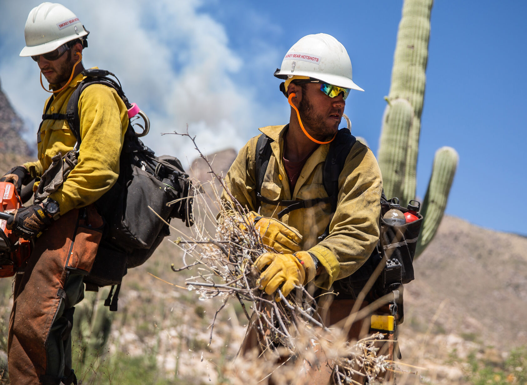
Adam Hutton with the Smokey Bear Hotshots of Ruidoso, New Mexico tosses away brush being cut near the mouth of Finger Rock Canyon as a precaution against the growing Bighorn Fire being fought in the Santa Catalina Mountain Range, on June 10, 2020.
Bighorn Fire in the Santa Catalina Mountains, 2020

The Bighorn Fire breaks onto the southern slopes of the Santa Catalina Mountains and burns over a pair of homes in the foothills just west of the Finger Rock Trailhead, ├█Ķųų▒▓ź, Ariz., June 10, 2020.
Bighorn Fire - ├█Ķųų▒▓ź

The Bighorn Fire churns through brush, creating a smoky mess in Pima Canyon and Finger Rock Canyon in the Santa Catalina Mountains north of ├█Ķųų▒▓ź on June 11, 2020.
Bighorn Fire in the Santa Catalina Mountains, 2020

A DC-10 air tanker (VLAT) drops fire retardant behind homes in the Cobblestone Estate during the Bighorn Fire in the Santa Catalina Mountains on June 11, 2020.
Bighorn Fire in the Santa Catalina Mountains, 2020

Residents watch a Neptune Aviation air tanker drop fire retardant behind the Santa Catalina foothills north of ├█Ķųų▒▓ź, Ariz. on June 11, 2020.
Bighorn Fire - ├█Ķųų▒▓ź

A hot shot fire crew hikes a ridge near Finger Rock Canyon in the Santa Catalina Mountains during the Bighorn Fire on June 11, 2020.
Bighorn Fire in the Santa Catalina Mountains, 2020

Keith Lencke of the Blue Ridge Hotshots watches the air attack on the Bighorn Fire in the Cobblestone Estates neighborhood in the Santa Catalina foothills on June 11, 2020.
Bighorn Fire in the Santa Catalina Mountains, 2020

Qin Chen talks with Tom Lemmons of the Pima County Sheriff's Office Auxiliary, about "Go" orders given to evacuate her home in the Cobblestone Estates neighborhood due to the Bighorn Fire in the Santa Catalina Mountains on June 11, 2020.
Bighorn Fire in the Santa Catalina Mountains, 2020

A Chinook helicopter dumps water on a slope during the Bighorn Fire in the Santa Catalina Mountains on June 11, 2020. Pinkish-red fire retardant coats the rock faces of the mountain range.
Bighorn Fire - ├█Ķųų▒▓ź

A DC-10 air tanker (VLAT) drops a line of retardant on a ridge above homes east of Pima Canyon in the Santa Catalina foothills during the Bighorn Fire on June 11, 2020.
Bighorn Fire in the Santa Catalina Mountains, 2020

A DC-10 VLAT makes a final drop in the fading light over the homes in the area between Swan and Alvernon during the daylong struggle to keep the Bighorn Fire out of the neighborhoods of the Santa Catalina Mountain foothills, ├█Ķųų▒▓ź, Ariz., June 11, 2020.
Bighorn Fire in the Santa Catalina Mountains, 2020

People watch from Oracle Road just north of the entrance to Catalina State Park as Chinook helicopters drop water on the Bighorn Fire which is burning for its seventh day in the western Santa Catalina mountain range, on June 12, 2020.
Bighorn Fire in the Santa Catalina Mountains, 2020

Smoke billows from the Bighorn Fire burning in the Pusch Ridge Wilderness, on June 12, 2020.
Bighorn Fire in the Santa Catalina Mountains, 2020
Two firefighting helicopters maneuver around one another while recharging at a dip site as the battle moves to the north to keep the Bighorn Fire from spreading, Oro Valley, Ariz., June 11, 2020.
Bighorn Fire in the Santa Catalina Mountains, 2020

A DC-10 VLAT drops below the ridge line as the aerial battle moves to the northwest and crews work to keep the Bighorn Fire from spreading through Catalina State Park, Oro Valley, Ariz., June 11, 2020.
Bighorn Fire in the Santa Catalina Mountains, 2020

A Chinook helicopter drops water on the line of flames advancing through grasslands at the northwestern foot of the Santa Catalinas as crews work to keep the Bighorn Fire from spreading through Catalina State Park, Oro Valley, Ariz., June 11, 2020.
Bighorn Fire in the Santa Catalina Mountains, 2020

The Bighorn Fire's northwestern front looms over homes as it burns into the central Santa Catalina Mountains, Oro Valley, Ariz., June 13, 2020.
Bighorn Fire in the Santa Catalina Mountains, 2020

A group of friends hangout on a high rock at Windy Point Vista while smoke from the Bighorn Fire flows over Mount Lemmon north of ├█Ķųų▒▓ź, Ariz. on June 14, 2020.
Bighorn Fire in the Santa Catalina Mountains, 2020

A Pima County Sheriff Auxiliary Volunteer motions for a four-wheel drive Type 3 fire engine from Three Points FD to proceed to Mount Lemmon on the Catalina Highway on June 15, 2020..
├█Ķųų▒▓ź Wildfires

A DC-10 air tanker drops fire retardant along Samaniego Ridge just west of Mt. Lemmon Sky Center during the Bighorn Fire burning west of Mt. Lemmon in the Santa Catalina Mountains north of ├█Ķųų▒▓ź on June 16, 2020.
Bighorn Fire in the Santa Catalina Mountains, 2020

A Sikorsky firefighting helicopter drops water along a ridge top as the flames from the Bighorn Fire work their way onto the northern slopes of the Santa Catalina Mountains, ├█Ķųų▒▓ź, Ariz., June 16, 2020.
Bighorn Fire in the Santa Catalina Mountains, 2020

The same wind whipping the flags outside the Fairfield Inn & Suites on Oracle Road is whipping up the flames and smoke of the Bighorn Fire, Oro Valley, Ariz., June 17, 2020.
Bighorn Fire in the Santa Catalina Mountains, 2020

Flames break through the smoke as a finger of the Bighorn Fire scorches its way through a canyon on the west side of the Santa Catalina Mountains above Oro Valley on June 17, 2020.
Bighorn Fire in the Santa Catalina Mountains, 2020

People use a wildlife exit along Oracle Road to get a view of the Bighorn Fire churning through heavy fuels like Ponderosa pines below Summerhaven on June 17, 2020.
Bighorn Fire in the Santa Catalina Mountains, 2020

The Bighorn Fire became of machine of heat and wind, consuming incinerating large stands of trees on June 17, 2020.
Bighorn Fire in the Santa Catalina Mountains, 2020

A firefighting helicopter flies over a smoke filled canyon as it shuttles water to a line between the Bighorn Fire and Oracle, ├█Ķųų▒▓ź, Ariz., June 18, 2020.
Bighorn Fire in the Santa Catalina Mountains, 2020

The Bighorn Fire burning in Ventana Canyon in the Santa Catalina Mountains as the fire became a daily spectacle, viewable from nearly anywhere in ├█Ķųų▒▓ź, on June 18, 2020.
Bighorn Fire in the Santa Catalina Mountains, 2020

Traffic on Sabino Canyon Road drives under the glow of he Bighorn Fire as it claims Ventana Canyon on the south slopes of the Santa Catalina Mountains on June 19, 2020.
Bighorn Fire in the Santa Catalina Mountains, 2020

Flames on the outer eastern walls of Ventana Canyon as the Bighorn Fire continues burning the Santa Catalina Mountains on June 20, 2020.
Bighorn Fire in the Santa Catalina Mountains, 2020

Smoke would lay-in over the city on days with calm winds as the Bighorn Fire methodically progressed through he Santa Catalina range. Photo taken on June 21, 2020 from "A" Mountain.
Bighorn Fire in the Santa Catalina Mountains, 2020

Flames from the Bighorn Fire climb over a ridge near Esperero Canyon, silhouetting a stand of Saguaros as the blaze marches east on June 23, 2020.
Bighorn Fire in the Santa Catalina Mountains, 2020

Smoke from the Bighorn Fire clings to the foothills of the eastern slopes of the Santa Catalina and Rincon mountains and the cottonwood-willow forest and mesquite bosque running along the San Pedro River Valley, Cascabel, Ariz., June 30, 2020.
Bighorn Fire in the Santa Catalina Mountains, 2020

Bighorn Fire scar area: Ca├▒ada del Oro basin looking south at Sanmaniego Ridge in the Santa Catalina Mountains north of ├█Ķųų▒▓ź on July 1, 2020. The summit of Mt Lemmon is at left.
Bighorn Fire in the Santa Catalina Mountains, 2020

Bighorn Fire scar area: Looking from East Ski Run toward Oracle Ridge, left, and Sanmaniego Ridge, right, in the Santa Catalina Mountains north of ├█Ķųų▒▓ź on July 10, 2020.
Bighorn Fire in the Santa Catalina Mountains, 2020

Summerhaven sits like an island surrounded Bighorn Fire scar and Aspen Fire scar from 2003 in these aerial photos from July 15, 2020. The Mt. Lemmon Fire Station and control road jut out from a U-shaped turn of Mt. Lemmon Highway at upper left.
Bighorn Fire in the Santa Catalina Mountains, 2020

Bighorn Fire scar area: Charred debris from the Bighorn Fire moves down the Ca├▒ada del Oro Wash after a monsoon storm on July 15, 2020.
Bighorn Fire in the Santa Catalina Mountains, 2020

A burned section of the Catalina Mountains seen near Aspen Vista Point, on Aug. 1, 2020.
Bighorn Fire in the Santa Catalina Mountains, 2020

Deymo Fernandez, left, and Sara Hernandez, look at a burn scar from the Bighorn Fire on the North side of Mount Lemmon outside the Iron Door Restaurant in Mount Lemmon on August 2, 2020..
Bighorn Fire in the Santa Catalina Mountains, 2020

The burn scar from the Bighorn Fire on a portion of the North side of Mount Lemmon, as seen from the Mount Lemmon Fire Station on August 2, 2020.
Bighorn Fire in the Santa Catalina Mountains, 2020

Gregg Sasek, dispersed recreation manager for the Coronado National Forest Santa Catalina Ranger District, demonstrates how ground along the Palisade Trail has been burnt out making it easy for hikers to sink a leg into the soil, on Aug. 12, 2020. Various dangers are still being accessed throughout the Coronado National Forest as a result of the Bighorn Fire.
Bighorn Fire in the Santa Catalina Mountains, 2020

A sign at the entrance to the Pima Canyon Trail warns hikers of dangers after the Bighorn Fire damages hiking areas on September 30, 2020.
Bighorn Fire in the Santa Catalina Mountains, 2020

Snow covers a burn scar from the Bighorn Fire in the Santa Catalina Mountains outside of Summerhaven, Ariz. on Nov. 9, 2020. The Mt. Lemmon General Store in Summerhaven got about 1-2 inches of snow early Monday, according to the National Weather Service.
Bighorn Fire in the Santa Catalina Mountains, 2020

Damage from the Bighorn Fire can be seen along the Marshall Gulch Trail on Mt. Lemmon in ├█Ķųų▒▓ź, Ariz. on May 25, 2021.
Bighorn Fire in the Santa Catalina Mountains, 2020

Rosalind Perera walks along the Aspen Trail where damage from the Bighorn Fire can be seen on Mt. Lemmon in ├█Ķųų▒▓ź, Ariz. on May 25, 2021.
Bighorn Fire in the Santa Catalina Mountains, 2020

Damage from the Bighorn Fire can be seen along the Aspen Trail on Mt. Lemmon in ├█Ķųų▒▓ź, Ariz. on May 25, 2021.