

The acreage torched by wildfires in УлшжжБВЅ was up sharply this year, but fire officials said it was still not a particularly bad season in terms of lives lost and structures burned in the blazes.
The 2020 wildfire season had burned just under 955,000 acres as of Wednesday, according to the УлшжжБВЅ Department of Forestry and Fire Management. Thatтs almost double the 520,000 acres that burned in 3,627 fires over the previous two years combined.
Wildfires such as the Bighorn Fire north of УлшжжБВЅ leave the ground charred and unable to absorb water, which can increase flood risks. тEven a light rain can produce devastating flash floods and mudflows, often with little warning,т Pima County officials warned. In this July 2020 video, a debris flow oozes down the CaУБada del Oro Wash.
The state recorded 2,357 fires statewide this year, of which 1,919 were caused by human activity.
тWe donтt say thereтs a fire season in УлшжжБВЅ anymore, because we are seeing fire activity in January, February, April and November,т said Tiffany Davila, public affairs officer for the УлшжжБВЅ Department of Forestry and Fire Management. тWe are seeing fires year-round now.т
People are also reading…
But unlike other Western states, Davila said УлшжжБВЅ has had only one confirmed fire-related death this year т when the pilot of a helicopter bringing supplies to the Polles fire was killed in the crash of his aircraft т and тmultipleт structures burned. California, by comparison, recorded 31 deaths and 10,488 structures damaged or destroyed by wildfires that have burned almost 4.2 million acres so far this year.
тWeтve had examples this year in УлшжжБВЅ, large fires that were quite destructive, and also large fires that are burning entirely within the range of variation that you would expect prior to white settlement of the West,т said Joe Trudeau, a Southwest conservation advocate at the Center for Biological Diversity.
Trudeau said there is тa tendency to equate all large fires with bad fires. And thatтs not necessarily the case.т
тWe have a range of fires out there,т he said of this yearтs season. тVery uncharacteristically severe fires, and then fires that are pretty much exactly what we want to see happening on the landscape.т
Experts blame the intensity of this yearтs fires on the relatively dry monsoon seasons of the past two years, which have created conditions that help fires spark and spread.
тIt all goes back to the lack of moisture we had over the winter,т Davila said.
While fire season usually ends in mid-July, the state was still battling several large fires into October. That could put fire prevention plans for 2021 at risk, as fire crews are forced to spend time and resources fighting fires now instead of doing the forest thinning and prescribed burns that could reduce potential fuel for next yearтs fires.
тItтs essentially deferring the risk into the future,т said Melanie Colavito, human dimensions specialist at the Ecological Restoration Institute at Northern УлшжжБВЅ University. тThe risk doesnтt go away. Because we werenтt able to get anything done this year, it means that just means we have this yearтs risk on top of next yearтs risk.т
Colavito said wildfires cannot be completely prevented т nor should they. Overgrown forests create conditions that allow for catastrophic fires if one breaks out, she said.
She and others point to efforts like the Four Forest Restoration Initiative, a federal initiative that seeks to manage 2.4 million acres in the Coconino, Kaibab, Tonto and Apache Sitgreaves national forests. Itтs an effort whose time has come, said Rep. Tom OтHalleran, D-Sedona.
тForest management has long been on the backburner at the federal level, which has led to devastating loss of life this year and contributed to the scourge of wildfires weтve seen across the desert Southwest this past decade,т OтHalleran said in a statement released by his office.
But fire, in a forest that is properly maintained, can be beneficial to the overall environment, Colavito said.
тI equate it to, like a predator, a wolf. If you remove all the wolves from a landscape, you have a lot of smaller species that kind of grow up in abundance,т Colvaito said. тFire is essentially a keystone process in these systems that helps to maintain its health.т
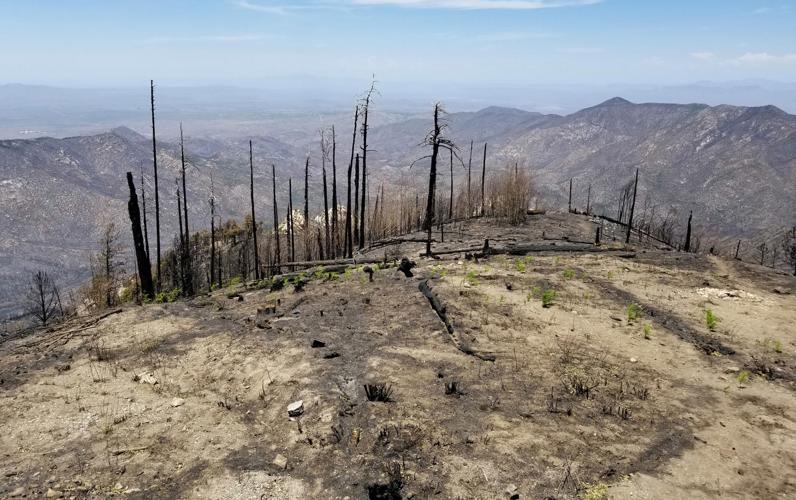
Photos: The Bighorn Fire burn scar in the Santa Catalina Mountains
Bighorn Fire Burn Scar, hiking trails

Gregg Sasek, dispersed recreation manager for the Coronado National Forest Santa Catalina Ranger District, demonstrates how ground along the Palisade Trail has been burnt out making it easy for hikers to sink a leg into the soil, on Aug. 12, 2020. Various dangers are still being accessed throughout the Coronado National Forest as a result of the Bighorn Fire. Pool photo by Josh Galemore / УлшжжБВЅ
Bighorn Fire Burn Scar, hiking trails

Santa Catalina District Ranger CJ Woodard looks at the burn scar caused by the Bighorn Fire along the Palisade Trail in the Santa Catalina Ranger District of the Coronado National Forest, on Aug. 12, 2020. Pool photo by Josh Galemore / УлшжжБВЅ
Bighorn Fire Burn Scar, hiking trails

A scorched tree along the Palisade Trail in the Santa Catalina Ranger District of the Coronado National Forest, on Aug. 12, 2020. Dangers including burnt vegetation, unstable trees and loose soil as a result of the Bighorn Fire are being accessed by the Forest Service before trails in the area are opened to the public. Pool photo by Josh Galemore / УлшжжБВЅ
Bighorn Fire Burn Scar, hiking trails

A tree uprooted by burnt roots and soil as a result of the Bighorn Fire along the Palisade Trail in the Santa Catalina Ranger District of the Coronado National Forest, on Aug. 12, 2020. Pool photo by Josh Galemore / УлшжжБВЅ
Bighorn Fire Burn Scar, hiking trails

Gregg Sasek, dispersed recreation manager with the Coronado National Forest Santa Catalina Ranger District, leads media and other Forest Service workers along the Palisade Trail to showcase various types of damage done to wilderness area as a result of the Bighorn Fire, on Aug. 12, 2020. Pool photo by Josh Galemore / УлшжжБВЅ
Bighorn Fire Burn Scar, hiking trails

A scorched tree along the Palisade Trail in the Santa Catalina Ranger District of the Coronado National Forest, on Aug. 12, 2020. Dangers including burnt vegetation, unstable trees and loose soil as a result of the Bighorn Fire are being accessed by the Forest Service before trails in the area are opened to the public. Pool photo by Josh Galemore / УлшжжБВЅ
Bighorn Fire Burn Scar, hiking trails

Ponderosa Pines charred by the Bighorn Fire stand along the Palisade Trail in the Santa Catalina Ranger District of the Coronado National Forest, on Aug. 12, 2020. Pool photo by Josh Galemore / УлшжжБВЅ
Bighorn Fire Burn Scar, hiking trails

A tree uprooted and burnt as a result of the Bighorn Fire along the Palisade Trail in the Santa Catalina Ranger District of the Coronado National Forest, on Aug. 12, 2020. Pool photo by Josh Galemore / УлшжжБВЅ
Bighorn Fire Burn Scar, hiking trails

Gregg Sasek, dispersed recreation manager with the Coronado National Forest Santa Catalina Ranger District, carries a combi-tool (a woodland fire tool which combines a shovel and pick) as he leads media and other Forest Service personnel along the Palisade Trail to showcase various types of damage done to wilderness area as a result of the Bighorn Fire, on Aug. 12, 2020. Pool photo by Josh Galemore / УлшжжБВЅ
Bighorn Fire Burn Scar, hiking trails

Forest Service personnel and media walk through a burn scar caused by the Bighorn Fire along the Palisade Trail in the Santa Catalina Ranger District of the Coronado National Forest, on Aug. 12, 2020. Pool photo by Josh Galemore / УлшжжБВЅ
Bighorn Fire Burn Scar, hiking trails

Forest Service personnel and media walk through a burn scar caused by the Bighorn Fire along the Palisade Trail in the Santa Catalina Ranger District of the Coronado National Forest, on Aug. 12, 2020. Pool photo by Josh Galemore / УлшжжБВЅ
Bighorn Fire Burn Scar, hiking trails

Gregg Sasek, dispersed recreation manager with the Coronado National Forest Santa Catalina Ranger District, leads media and other Forest Service workers along the Palisade Trail to showcase various types of damage done to wilderness area as a result of the Bighorn Fire, on Aug. 12, 2020. Pool photo by Josh Galemore / УлшжжБВЅ
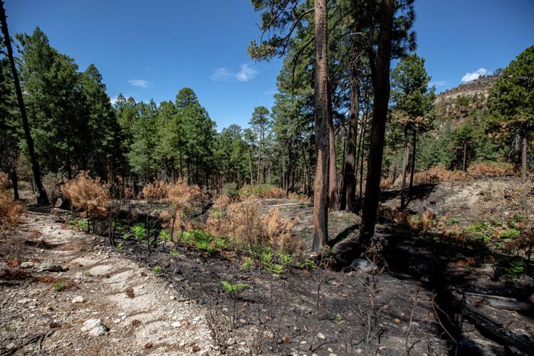
Bighorn Fire Burn Scar, hiking trails

A fern sprouts from the soil in a burnt out area along the Palisade Trail in the Santa Catalina Ranger District of the Coronado National Forest, on Aug. 12, 2020. Pool photo by Josh Galemore / УлшжжБВЅ
Bighorn Fire Burn Scar, hiking trails

Gregg Sasek, dispersed recreation manager with the Coronado National Forest Santa Catalina Ranger District, checks tree tops for signs of burn while leading media and other Forest Service workers along the Palisade Trail to showcase various types of damage done to wilderness area as a result of the Bighorn Fire, on Aug. 12, 2020. Pool photo by Josh Galemore / УлшжжБВЅ
Bighorn Fire Burn Scar, hiking trails

A burn scar along the Palisade Trail in the Santa Catalina Ranger District of the Coronado National Forest, on Aug. 12, 2020. Pool photo by Josh Galemore / УлшжжБВЅ
Bighorn Fire Burn Scar, hiking trails

A tree base scorched by the Bighorn Fire along the Palisade Trail in the Santa Catalina Ranger District of the Coronado National Forest, on Aug. 12, 2020. The weakening of the base makes it easier for trees to fall and are a serious danger to hikers. Pool photo by Josh Galemore / УлшжжБВЅ
Bighorn Fire Burn Scar, hiking trails

Gregg Sasek, dispersed recreation manager with the Coronado National Forest Santa Catalina Ranger District, walks by a "leaner" (an uprooted tree hung up on another tree or object) as he leads media and other Forest Service workers along the Palisade Trail to showcase various types of damage done to wilderness area as a result of the Bighorn Fire, on Aug. 12, 2020. Pool photo by Josh Galemore / УлшжжБВЅ
Bighorn Fire Burn Scar, hiking trails

A burn scar from the Bighorn Fire along a hilltop near the Palisade Trail in the Santa Catalina Ranger District of the Coronado National Forest, on Aug. 12, 2020. Pool photo by Josh Galemore / УлшжжБВЅ
Bighorn Fire Burn Scar, hiking trails

Scorched pine needles along the Palisade Trail in the Santa Catalina district of the Coronado National Forest, on Aug. 12, 2020. Pool photo by Josh Galemore / УлшжжБВЅ
Bighorn Fire

Bighorn Fire scar north of Summerhaven, Ariz, right, on July 15, 2020. The Mt. Lemmon Fire station is top center in the photo.
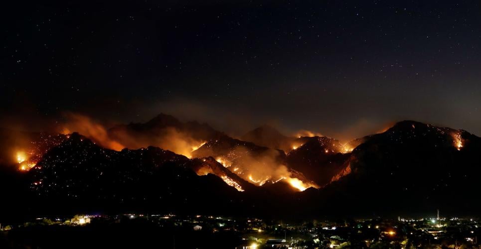
Bighorn Fire

Bighorn Fire in the Santa Catalina Mountains below Summerhaven, Ariz, right, on July 15, 2020.
Bighorn Fire

Bighorn Fire scar in the Santa Catalina Mountains north of Summerhaven (lower right) on July 15, 2020.
Bighorn Fire

Bighorn Fire scar in the Santa Catalina Mountains below the town of Summerhaven on July 15, 2020.
Bighorn Fire

The Mt. Lemmon Control Road cuts through the Bighorn Fire scar on the north side of the Santa Catalina Mountains near Oracle, Ariz., on July 15, 2020.
Bighorn Fire

Bighorn Fire scar below Mt. Lemmon in the Santa Catalina Mountains on July 15, 2020.
Bighorn Fire

Bighorn Fire scar area: CaУБada del Oro basin looking south at Samaniego Ridge in the Santa Catalina Mountains north of УлшжжБВЅ on July 1, 2020. The summit of Mt Lemmon is at left.
Bighorn Fire

The Bighorn Fire scar area shown looking from East Ski Run toward Oracle Ridge, left, and Sanmaniego Ridge, right, in the Santa Catalina Mountains north of УлшжжБВЅ.
Bighorn Fire

Bighorn Fire scar area: South face of Mt Kimball on July 3, 2020, in the Santa Catalina Mountains north of УлшжжБВЅ.
Bighorn Fire

Bighorn Fire scar area: Regional Flood Control Staff installing a new real-time ALERT rainfall monitoring site in the burn area in the Santa Catalina Mountains north of УлшжжБВЅ in July, 2020. These are the backbone of the flash flood warning system.
Bighorn Fire

Charred debris from the Bighorn Fire moves down the CaУБada del Oro Wash after a monsoon storm on July 15, 2020.
Bighorn Fire

Charred debris from the Bighorn Fire moves down the CaУБada del Oro Wash after a monsoon storm on July 15, 2020.


