Even though УлшжжБВЅ gets most of its water from the Colorado River, its top water official says the city can withstand the deepest cut itтs likely to get from that supply in the foreseeable future.
This assurance comes after researchers recently warned the Colorado River Basin could face severe future cuts in water supplies due to climate change and other pressures.
The тworst plausible scenarioт of a cut the city could face is 50% of its total Colorado River allocation from the Central УлшжжБВЅ Project canal system, said former УлшжжБВЅ Water Director Tim Thomure. He still oversees the utility as interim assistant city manager.
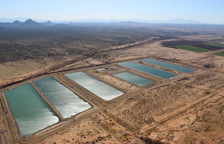
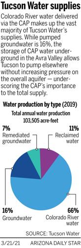
Much of the water that could be cut is currently not used to serve customers, he said. The city stores more than one-third of its CAP supply in large basins for future use. From there, the water sinks into the ground to replenish, or recharge, the aquifer.
People are also reading…
While УлшжжБВЅ may have to pump more groundwater in the future because of CAP cuts, Thomure said the aquifer typically has been naturally replenished by enough rainfall and runoff to compensate for the most likely worst-case shortfalls in CAP deliveries.
But a big unknown clouding УлшжжБВЅтs future water picture is how climate change might interfere with natural recharge of the aquifer by reducing rainfall and increasing evaporation.
A new federal study warns that continued heating of the planet could reduce natural recharge, noted Kathy Jacobs, a top University of УлшжжБВЅ climate scientist.
That calls into question the cityтs estimates of how much recharge weтll get in the future. Jacobsт point is "well taken,т Thomure said.
тResilient positionт even with a 50% cut
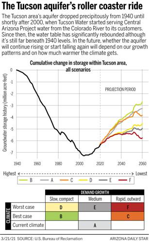
The longstanding concern about possible cuts to the CAP is that a return to heavy pumping would reverse a trend of significantly rising aquifer levels under the city since the CAP went online here in 2001.
Since that year, УлшжжБВЅ Waterтs groundwater pumping has decreased dramatically.
УлшжжБВЅтs annual CAP allocation is 144,191 acre-feet т enough to serve about 575,000 households for a year.
However, the biggest share of CAP water that the city would lose is now being used to recharge the aquifer through the basins in Avra Valley west of УлшжжБВЅ and on Pima Mine Road south of УлшжжБВЅ.
Thatтs why a 50% reduction in CAP wouldnтt require enough groundwater pumping to cause significant problems with the aquifer, such as subsidence, Thomure said. Subsidence is the collapse of the ground surface as water is withdrawn from underneath.
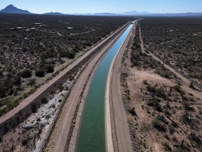
The Central УлшжжБВЅ Project is a 336-mile canal in УлшжжБВЅ that supplies Colorado River water for the Phoenix and УлшжжБВЅ area, agriculture and several Native-American tribes. Construction began in 1973 and was substantially complete by 1994. This portion is located near Sandario Road and Mile Wide Road west of УлшжжБВЅ on March 17, 2021. Video by: Mamta Popat / УлшжжБВЅ
The natural replenishment of the aquifer in УлшжжБВЅ Waterтs service area would compensate for the pumping the utility would do, Thomure said. тWe can be in a really, still resilient position with up to a 50% cut,т he said.
тThe worst case scenario is that weтre pumping 25,000 acre feet a year,т half the water that naturally recharges the aquifer in the service area, Thomure said.
Jacobs, a former УлшжжБВЅ office director for the УлшжжБВЅ Department of Water Resources, said she agrees with Thomureтs forecast of how much CAP water the city would lose in the worst case.
She also agrees with other experts who say УлшжжБВЅ Water has done a good job in managing its water resources, in part by recharging much of its CAP supply.
УлшжжБВЅ Water has access to a significant amount of groundwater today, due to its extensive wellfields inside the city and landholdings and wellfields in the Avra Valley, she said.
In fact, УлшжжБВЅ has access to the тlargest allocation of groundwater for any utility in the state,т and the largest CAP water allocation of any УлшжжБВЅ utility, she said.
Together, the CAP and groundwater allow УлшжжБВЅ Water to be designated as having an assured, 100-year water supply т a state requirement for it to serve new development.
Federal study shows potential pitfalls
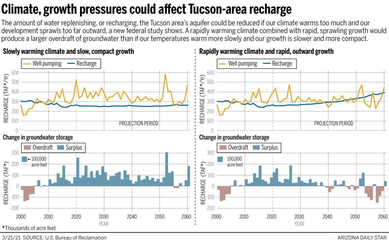
But the new study done by the U.S. Bureau of Reclamation concluded thereтs likely to be less water in our aquifer if УлшжжБВЅ-area temperatures rise fast enough and development spreads out far enough.
That calls into question whether the numbers УлшжжБВЅ Water uses for natural recharge will be borne out by future climate conditions, said Jacobs, who is director of the UAтs Center for Climate Change Adaptation, Science and Solutions.
Responding to Jacobs, Thomure agreed future projections indicate the regionтs climate will get hotter and possibly drier.
But itтs тnotoriously difficultт to predict how climate change will affect Southern УлшжжБВЅтs monsoon, he said, and itтs a major source of rainfall and recharge here.
тRegardless, the conservative assumption is that future natural recharge rates may decrease, or at least become more variable,т he said. тTherefore, our working assumption of 50,000 acre-feet per year of natural groundwater recharge in our supply wellfields could indeed decrease over time.т
Uncertainty about recharge isnтt an immediate crisis т itтs a long-term issue, Jacobs said.
If the water table does start falling again, subsidence could occur and pumping must be planned to minimize it, she said.
тThey may need to be more creative in the way they manage their wellfields,т she said . тIf your objective is minimizing subsidence, you want to properly manage your withdrawals in areas of subsidence risk.т
тThe issue is that when you are in a developed area with a lot of infrastructure, subsidence of any magnitude can cause damage,т Jacobs said. тEven small changes in the land surface can break water and sewer pipelines, roadways and flood control structures.т
River entering uncharted territory
Thomureтs comments come as the river enters a new era of unknowns, led by warnings coming from a recent study by Utah State University about the Colorado River Basin.
That study warned that if river flows drop 6.5% for every 1.8 degree Fahrenheit temperature increase, as some researchers project, тaggressive commitments to water conservationт will be needed in the Lower and Upper Colorado River Basin states.
Such conservation would provide a minimal level of water storage security in the regionтs two big reservoirs, Lake Powell and Lake Mead, the study said.
For the three Lower Basin states, including УлшжжБВЅ, cutbacks of up to 40% of their Colorado River supplies may be necessary to keep reservoirs from falling too low, it said.
That dire conclusion assumes the riverтs flows keep declining as theyтve done since 2000, due in part to climate change.
If river flows maintain their current, reduced levels, cutbacks will still be needed, but they wouldnтt be as severe as if the flows keep dropping, the study said.
Politically, the river is also entering uncharted territory. The seven river basin states including УлшжжБВЅ are preparing to renegotiate guidelines for managing the systemтs reservoirs that expire in 2026, 19 years after they were approved.
The states also agreed in 2019 to a separate drought contingency plan to try to stabilize water levels at Lakes Mead and Powell by agreeing to reduce their take from the river as the lakes fall below certain levels. That pact also expires in 2026 and will have to be revisited and most likely revised.
Thomure called the Utah State study тwell done.т It achieves its stated goal, тto put out some provocative ideas and with the express intent of having people think more broadly and more creatively as we go into next negotiations on the river,т he said.
тThey make a lot of assumptions and some of their conclusions are drawn from stacking worst-case scenarios on top of each other. Thatтs not a flaw, but itтs something that needs to be understood,т Thomure said.
тItтs not an unreasonable study but itтs also not making any specific prediction about the future. Itтs providing a range of possible outcomes.т
How the worst case would play out
For now, УлшжжБВЅ stands to skate through the cuts approved in the 2019 drought plan.
At most, it would lose only 11% of its total CAP supply under that plan, and only when Lake Mead drops to or below 1,025 feet, about 60 feet lower than todayтs level.
But negotiations over revising the 2007 guidelines and the 2019 drought plan could lead to agreements for larger cuts if the riverтs future stays gloomy.
Thomureтs view of the worst-case scenario for УлшжжБВЅ is based on the possibility of the entire CAP т which also serves Phoenix, farms and tribes т losing 67% of its total supply in the future.
Thatтs more than the 2019 drought plan envisions. That plan would cut CAP at most by nearly half its total supply т 720,000 acre-feet т after seven years if Lake Mead dropped low enough.
If CAP were cut 67%, municipal and tribal CAP users would probably lose about 472,000 acre-feet total, Thomure said. Thatтs enough to serve more than 1.5 million households for a year.
Based on УлшжжБВЅтs proportional share of the entire CAP supply, the city would lose about 47% of its allocation, said Thomure.
He chose to up the worst-case cut to 50% to simplify calculations for planning purposes.
With a 50% cut, УлшжжБВЅ would have a little less than 75,000 acre-feet of CAP left.
But since the utility uses around 110,000 acre-feet annually т its total 2019 deliveries were 103,000 т and it gets another 10,000 acre-feet annually in reclaimed water, that means it would face a gap of no more than 25,000 acre-feet to be made up by pumping, Thomure said.
He said natural recharge will allow the utility to тphysically and sustainably pump twice this much groundwater indefinitely.т
The 50,000 acre-feet recharge level was first mentioned in a 2004 city of УлшжжБВЅ 100-year water plan. тFor planning purposes, it is conservatively estimated that УлшжжБВЅ Water can withdraw 50,000 acre-feet of ground water each year without causing significant water-level declines within its projected service area,т the plan said. That calculation was supported by a groundwater model created and used by the УлшжжБВЅ Department of Water Resources, Thomure said.
An Even deeper cut is called survivable
Even a 75% cut in CAP deliveries could be handled without substantial pumping increases, Thomure said.
УлшжжБВЅ Water then would have a little more than 40,000 acre-feet left, or only enough to serve 160,000 households for a year. It would have to pump around 60,000 acre-feet, more than its available natural recharge.
But to compensate for that, УлшжжБВЅ Water would be able to tap into treated sewage effluent it has started recharging into the aquifer for its Santa Cruz River Heritage Project, begun in 2019, and its Southeast Houghton Area Recharge Project, started last year.
These calculations will be updated for a new тOne Water 2100т city plan, scheduled for completion in 18 to 24 months, Thomure said.
That plan will also contain a detailed assessment of the risks to the cityтs water supply from climate change т the first such detailed analysis the utility has done, he said.
Beyond the natural recharge it gets annually, the city legally has the rights to pump a total of 3.3 million acre-feet of naturally replenished groundwater already in the aquifer.
Thatтs enough to serve the cityтs customers for more than 200 years, УлшжжБВЅ Water says.
However, Thomure said the utility doesnтt want to pump that much groundwater because of the risks of subsidence and poorer water quality as the aquifer declines.
The city also has the rights to pump more than 800,000 additional acre-feet of recharged CAP water that УлшжжБВЅ Water and the УлшжжБВЅ Water Banking Authority have placed in the ground here.
While Thomure said a 75% cut in CAP is not a plausible scenario, if it did happen, the city could still manage its water supply sustainably and indefinitely, he said.
тThis scenario is тbeyond worst case,т yet the community is still OK,т he said.
But the city is revisiting its assumption of recharge availability as it prepares its One Water 2100 plan, Thomure added. It continuously monitors and adjusts groundwater operations in response to a variety of factors including water levels and water quality.
тThat is why our robust and continued investment in our groundwater infrastructure is critical, even though groundwater is no longer our primary supply source,т Thomure said.
Photos: Water fills the desert at these spots around УлшжжБВЅ
Lakeside Park, УлшжжБВЅ

A father fishes with his two sons at Chuck Ford Lakeside Park, 8201 E. Stella Rd., in УлшжжБВЅ, Ariz. on Nov. 17, 2020. Chuck Ford Lakeside Park, an urban lake on the southeast side of town, is a popular spot for walking and fishing. The lake is stocked with catfish, trout, bass and sunfish.
Lakeside Park, УлшжжБВЅ

A duck runs on water at Chuck Ford Lakeside Park, 8201 E. Stella Rd., in УлшжжБВЅ, Ariz. on Nov. 17, 2020. Chuck Ford Lakeside Park, an urban lake on the southeast side of town, is a popular spot for walking and fishing.
Lakeside Park, УлшжжБВЅ

While fishing with family members, Jose Saenz places a caught rainbow trout in a basket at Chuck Ford Lakeside Park, 8201 E. Stella Rd., in УлшжжБВЅ, Ariz. on Nov. 17, 2020. Chuck Ford Lakeside Park, an urban lake on the southeast side of town, is a popular spot for walking and fishing. The lake is stocked with catfish, trout, bass and sunfish.
Lakeside Park, УлшжжБВЅ

A fisherman waits for a fish to bite their lure at Chuck Ford Lakeside Park, 8201 E. Stella Rd., in УлшжжБВЅ, Ariz. on Nov. 17, 2020. Chuck Ford Lakeside Park, an urban lake on the southeast side of town, is a popular spot for walking and fishing.
Lakeside Park, УлшжжБВЅ

The reflection of Chuck Ford Lake shows in avid fisherman Richard Espinoza's sunglasses while Espinoza fishes for trout at Chuck Ford Lakeside Park, 8201 E. Stella Rd., in УлшжжБВЅ, Ariz. on Nov. 17, 2020. Chuck Ford Lakeside Park, an urban lake on the southeast side of town, is a popular spot for walking and fishing. The lake is stocked with catfish, trout, bass and sunfish.
Lakeside Park, УлшжжБВЅ
A person walks around the lake at Chuck Ford Lakeside Park, 8201 E. Stella Rd., in УлшжжБВЅ, Ariz. on Nov. 17, 2020. Chuck Ford Lakeside Park, an urban lake on the southeast side of town, is a popular spot for walking and fishing.
Lakeside Park, УлшжжБВЅ

While fishing with her family, Aziza Ramirez waits for a fish to bite her lure at Chuck Ford Lakeside Park, 8201 E. Stella Rd., in УлшжжБВЅ, Ariz. on Nov. 17, 2020. Chuck Ford Lakeside Park, an urban lake on the southeast side of town, is a popular spot for walking and fishing.
Agua Caliente Park, УлшжжБВЅ

Several resident ducks ply the waters of the main pond as sun sets at Agua Caliente Park, УлшжжБВЅ, Ariz., November 17, 2020. The park is one of the most popular bird watching sites in the county.
Agua Caliente Park, УлшжжБВЅ

Park goers stop for photos of a pack of javalina roaming the park just before sunset at Agua Caliente Park, УлшжжБВЅ, Ariz., November 17, 2020.
Agua Caliente Park, УлшжжБВЅ

A pack of javalina rush for the trees after getting spooked while nosing around the lawn for food at Agua Caliente Park, УлшжжБВЅ, Ariz., November 17, 2020.
Agua Caliente Park, УлшжжБВЅ

The sun goes down and the bats come out over the main pond at Agua Caliente Park, УлшжжБВЅ, Ariz., November 17, 2020.
Agua Caliente Park, УлшжжБВЅ

The island in the main pond has been renovated and the bridge completely replaced at Agua Caliente Park, УлшжжБВЅ, Ariz., November 17, 2020.
Agua Caliente Park, УлшжжБВЅ

A park patron and his dog stroll along the paths on the shores of the main pond at Agua Caliente Park, УлшжжБВЅ, Ariz., November 17, 2020.
Agua Caliente Park, УлшжжБВЅ

Some of the wetland vegetation is beginning to reassert a hold after months of work to restore and renovate the main pond at Agua Caliente Park, УлшжжБВЅ, Ariz., November 17, 2020.
Agua Caliente Park, УлшжжБВЅ

Bernie Kanavage and Toby take a break from their evening walk on the bank of the main pond at Agua Caliente Park, УлшжжБВЅ, Ariz., November 17, 2020. The main pond was recently restored, a major renovation that shut the park down for months in late 2019.
Agua Caliente Park, УлшжжБВЅ

A pair of park goers get close-ups from an obliging duck along the shores of the main pond at Agua Caliente Park, УлшжжБВЅ, Ariz., November 17, 2020.
Agua Caliente Park, УлшжжБВЅ

Sun set over the main pond at Agua Caliente Park, УлшжжБВЅ, Ariz., November 17, 2020.
Santa Cruz River, УлшжжБВЅ

Water flows in the Santa Cruz River south of downtown УлшжжБВЅ, Ariz. on November 16, 2020. The addition of reclaimed water to the Santa Cruz River has hastened the return of wildlife.
Santa Cruz River, УлшжжБВЅ

A cyclist rides along The Loop as water flows in the Santa Cruz River near the Crossroads at Silverbell District Park, in Marana, Ariz. on November 18, 2020.
Santa Cruz River, УлшжжБВЅ
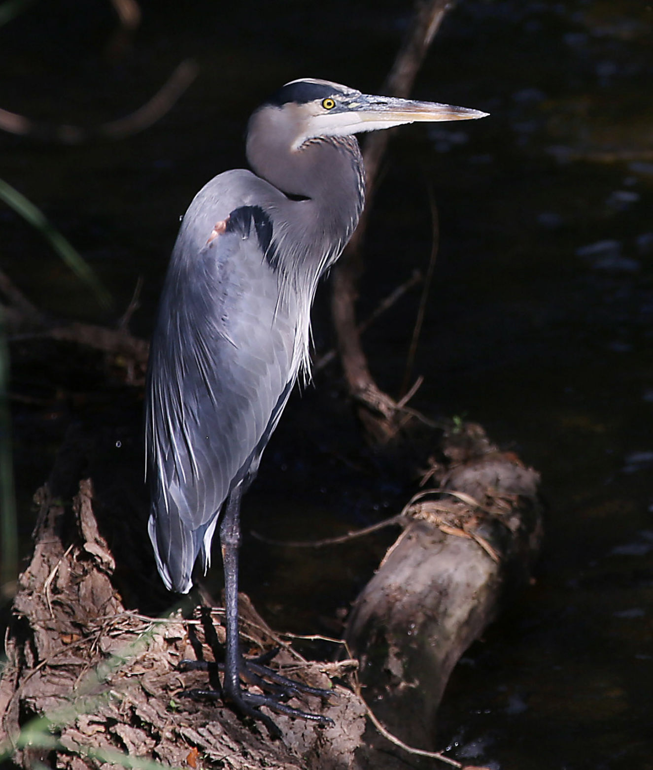
A heron sits by the water in the Santa Cruz River near the Crossroads at Silverbell District Park, in Marana, Ariz. on November 18, 2020.
Santa Cruz River, УлшжжБВЅ

Water flows in the Santa Cruz River south of downtown УлшжжБВЅ, Ariz. on November 16, 2020.
Santa Cruz River, УлшжжБВЅ

Water flows in the Santa Cruz River near the Crossroads at Silverbell District Park, in Marana, Ariz. on November 18, 2020.
Santa Cruz River, УлшжжБВЅ

Water flows in the Santa Cruz River south of downtown УлшжжБВЅ, Ariz. on November 16, 2020.
Santa Cruz River, УлшжжБВЅ
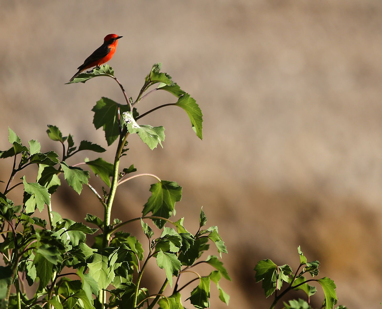
A Vermillion flycatcher rests on a branch along the Santa Cruz River south of downtown УлшжжБВЅ, Ariz. on November 16, 2020.
Santa Cruz River, УлшжжБВЅ

A bird rests on a branch of a tree along the Santa Cruz River near the Crossroads at Silverbell District Park, in Marana, Ariz. on November 18, 2020.
Santa Cruz River, УлшжжБВЅ

Water flows in the Santa Cruz River near the Crossroads at Silverbell District Park, in Marana, Ariz. on November 18, 2020.
Sweetwater Wetlands, УлшжжБВЅ

Water flows near the entrance at the Sweetwater Wetlands, 2511 W. Sweetwater Drive, in УлшжжБВЅ, Ariz. on November 17, 2020.
Sweetwater Wetlands, УлшжжБВЅ

Ducks swim in one of the bodies of water at the Sweetwater Wetlands, 2511 W. Sweetwater Drive, in УлшжжБВЅ, Ariz. on November 17, 2020.
Sweetwater Wetlands, УлшжжБВЅ

Libby Sullivan, left, and Sue Bridgemon walk along one of the trails at the Sweetwater Wetlands, 2511 W. Sweetwater Drive, in УлшжжБВЅ, Ariz. on November 17, 2020.
Sweetwater Wetlands, УлшжжБВЅ

Libby Sullivan, left, and Sue Bridgemon do some birdwatching at the Sweetwater Wetlands, 2511 W. Sweetwater Drive, in УлшжжБВЅ, Ariz. on November 17, 2020.
Sweetwater Wetlands, УлшжжБВЅ

A duck flight at Sweetwater Wetlands, 2511 W. Sweetwater Drive, in УлшжжБВЅ, Ariz. on November 17, 2020.
Sweetwater Wetlands, УлшжжБВЅ

Cattails grow near a body of water at the Sweetwater Wetlands, 2511 W. Sweetwater Drive, in УлшжжБВЅ, Ariz. on November 17, 2020.
Sweetwater Wetlands, УлшжжБВЅ

Ren Sullivan watches a group of ducks at the Sweetwater Wetlands, 2511 W. Sweetwater Drive, in УлшжжБВЅ, Ariz. on November 17, 2020.
Sweetwater Wetlands, УлшжжБВЅ

Sunlight breaks through the trees at the Sweetwater Wetlands, 2511 W. Sweetwater Drive, in УлшжжБВЅ, Ariz. on November 17, 2020.
Reid Park, УлшжжБВЅ

James DeDitius points at ducks as he sits with caregiver Mary Figueroa on a bench next to a lake at Reid Park, on March 17, 2020.
Reid Park, УлшжжБВЅ
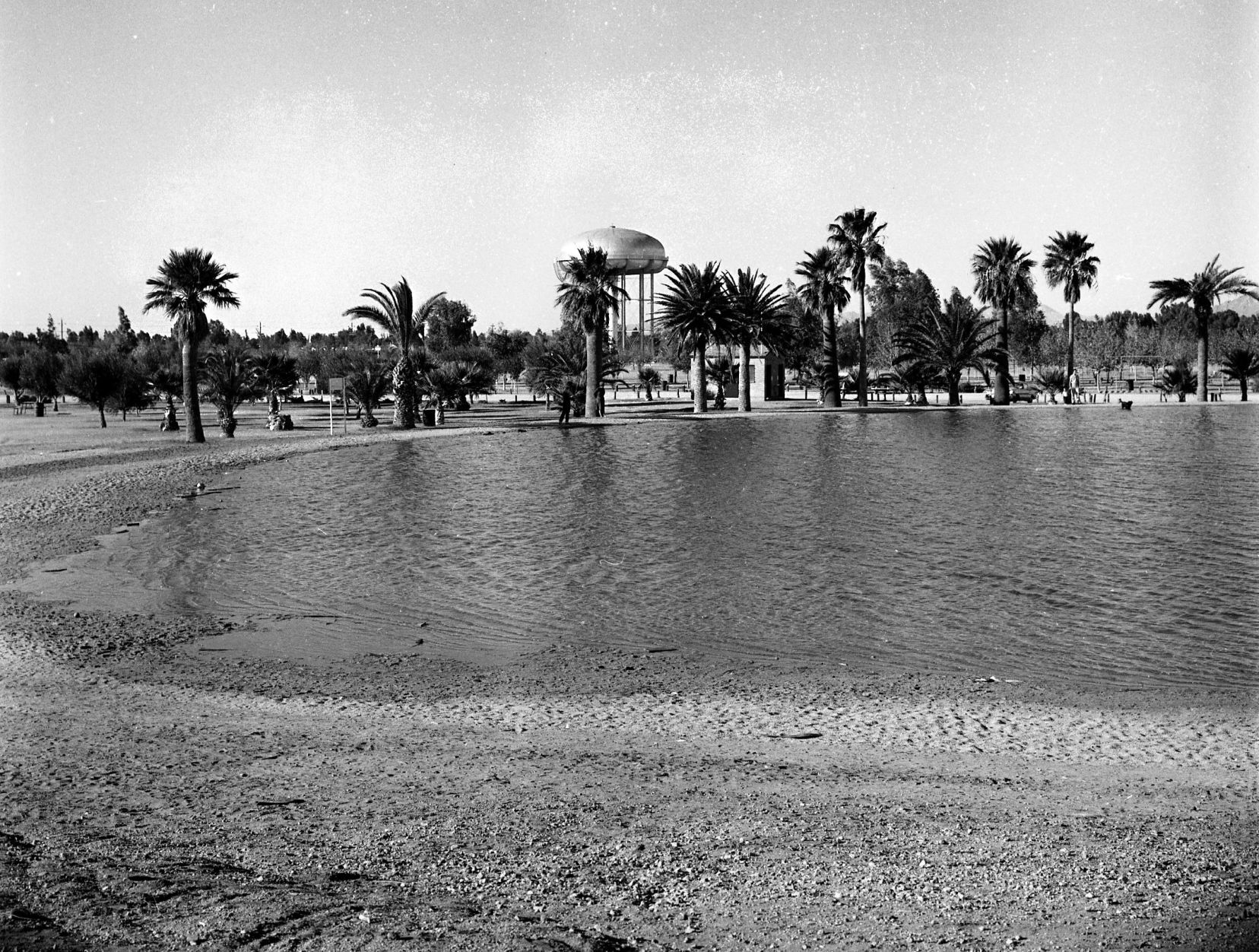
The city's new 4.5 million gallon lake and storage basin at Randolph (now Reid) Park, УлшжжБВЅ, in December, 1959.
Silverbell Lake, УлшжжБВЅ

The УлшжжБВЅ Game and Fish Department brought in 14,300 pounds of catfish from Arkansas to restock 21 lakes in the Core Community Fishing Program in УлшжжБВЅ and Phoenix. These catfish were dumped into Silverbell Lake on April 03, 2015.
Silverbell Lake, УлшжжБВЅ

Jim Skay fishes at Silverbell Lake, on March 13, 2020.
Silverbell Lake, УлшжжБВЅ

In this 2016 photo, Nathaniel Ortega, left, grins while his grandfather Michael Ortega helps remove a fish from his line during a fishing clinic at Silverbell Lake, located in Christopher Columbus Park at 4600 N. Silverbell Rd. in УлшжжБВЅ, Ariz. Nathaniel's catch was the first catfish of the day.
Sahuarita Lake

A person walks along Sahuarita Lake on March 5, 2020.
Sahuarita Lake

Ted Moreno reels in a line while fishing at Lake Sahuarita, on March 5, 2020. Moreno, who lives in УлшжжБВЅ generally goes between LakeТ Sahuarita and Kennedy Lake to fish for trout during the fall and winter months.
Sahuarita Lake

Sahuarita Lake in the town of Sahuarita south of УлшжжБВЅ is popular with anglers, walkers, cyclists and others and its waters range from dazzling blue to aquamarine depending on the light.
Sahuarita Lake

In this 2001 photo, Dan Hampshire works on the top designs of a 34-foot monument tower at the entrance to Rancho Sahuarita, an 8,000 home project on 2,500 acres that includes a yet-to-be-filled 10-acre lake (in background).
Sahuarita Lake

In this 2013 photo, a couple walk around Sahuarita Lake Park, 15466 S. Rancho Sahuarita Blvd.

Tim Thomure

Kathy Jacobs
Contact reporter Tony Davis at tdavis@tucson.com or 349-0350.

Tony Davis
Reporter